Brookville, Indiana
Utseende
| Brookville | |
| town | |
Lew Wallaces födelsehus (ur Lew Wallace: An Autobiography, 1906).
| |
| Land | |
|---|---|
| Delstat | Indiana |
| County | Franklin County |
| Höjdläge | 203 m ö.h. |
| Koordinater | 39°25′23″N 85°0′46″V / 39.42306°N 85.01278°V |
| Yta | 4,0 km² (2010) |
| - land | 3,9 km² |
| - vatten | 0,1 km² |
| Folkmängd | 2 596 (2010) |
| Befolkningstäthet | 666 invånare/km² |
| Tidszon | EST (UTC-5) |
| - sommartid | EDT (UTC-4) |
| ZIP-kod | 47012 |
| Riktnummer | 765 |
| FIPS | 1808182 |
| Geonames | 4254999 |
|
Ortens läge i Indiana
| |
|
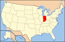
Indianas läge i USA
| |
Brookville är administrativ huvudort i Franklin County i Indiana.[1][2] Ortnamnet hedrar modern till Brookvilles grundare Jesse Brooks Thomas.[3] Vid 2010 års folkräkning hade Brookville 2 596 invånare.[4]
Kända personer från Brookville
[redigera | redigera wikitext]- John St. John, politiker
- Lew Wallace, militär
Källor
[redigera | redigera wikitext]- ^ Indiana County Map with County Seat Cities. Geology.com Geoscience News and Information. Läst 10 augusti 2017.
- ^ Brookville, IN. Map Quest. Läst 10 augusti 2017.
- ^ Profile for Brookville, Indiana Arkiverad 16 juni 2017 hämtat från the Wayback Machine.. ePodunk. Läst 10 augusti 2017.
- ^ 2010 Census Population of Brookville, Indiana Arkiverad 10 augusti 2017 hämtat från the Wayback Machine.. Census Viewer. Läst 10 augusti 2017.
|


