Santo Tomas, La Union
Appearance
Santo Tomas | |
|---|---|
 | |
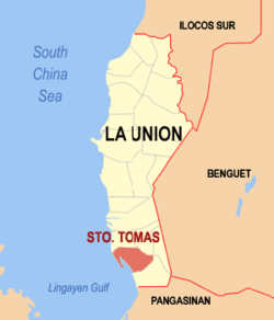
 Location in the province o La Union | |
| Coordinates: 16°15′49″N 120°23′38″E / 16.26361°N 120.39389°ECoordinates: 16°15′49″N 120°23′38″E / 16.26361°N 120.39389°E | |
| Kintra | |
| Region | Ilocos (Region I) |
| Province | La Union |
| District | 2nd District |
| Foondit | 1764 |
| Barangays | 24 |
| Govrenment | |
| • Mayor | Marietta Calonge Carbonell |
| Area | |
| • Total | 64.00 km2 (24.71 sq mi) |
| Population (2010)[3] | |
| • Total | 35,999 |
| • Density | 560/km2 (1,500/sq mi) |
| Time zone | UTC+8 (PST) |
| ZIP code | 2505 |
| Dialin code | 72 |
| Income cless | 4th class[4] |
Santo Tomas (Ilocano: Ili ti Santo Tomas; Pangasinan: Baley na Santo Tomas),is a fowert class municipality in the province o La Union, Philippines. Accordin tae the 2010 census, it haes a population o 35,999 fowk.[3] Sooth o Agoo an north o Rosario, the municipality is 230 kilometre (140 mi) frae Manila, the passagewey o Manila-Ilocos Route.
Barangays
[eedit | eedit soorce]| Rank | Barangay | Population | Rank | Barangay | Population | |
|---|---|---|---|---|---|---|
| 1 | Patac | 2,978 | 14 | Cupang | 1,398 | |
| 2 | Tubod | 2,485 | 15 | Balaoc | 1,373 | |
| 3 | Damortis | 2,265 | 16 | Lomboy | 1,319 | |
| 4 | Bail | 2,227 | 17 | Tococ | 1,140 | |
| 5 | Namboongan | 2,214 | 18 | Raois | 1,046 | |
| 6 | Namonitan | 2,050 | 19 | Fernando | 1,003 | |
| 7 | Casantaan | 1,991 | 20 | Balsaan | 875 | |
| 8 | Ubagan | 1,786 | 21 | Linong | 634 | |
| 9 | Poblacion | 1,696 | 22 | Ambitacay | 581 | |
| 10 | Casilagan | 1,557 | 23 | Narvacan | 559 | |
| 11 | Pongpong | 1,504 | 24 | Malabago | 449 | |
| 12 | Cabaruan | 1,454 | Santo Tomas Total | 35,999 | ||
| 13 | Baybay | 1,415 | ||||
Demographics
[eedit | eedit soorce]| Population census of Santo Tomas | ||
|---|---|---|
| Year | Pop. | ±% p.a. |
| 1990 | 27,352 | — |
| 1995 | 28,192 | +0.61% |
| 2000 | 31,204 | +2.05% |
| 2007 | 33,604 | +1.06% |
| 2010 | 35,999 | +2.32% |
| Source: National Statistics Office[3][6] | ||
References
[eedit | eedit soorce]- ↑ "Cities". Quezon City, Philippines: Department of the Interior and Local Government. Archived frae the original on 9 Mairch 2013. Retrieved 29 November 2012.
- ↑ "Province: La Union". PSGC Interactive. Makati City, Philippines: National Statistical Coordination Board. Archived frae the original on 24 November 2007. Retrieved 29 November 2012.
- ↑ a b c "Total Population by Province, City, Municipality and Barangay: as of May 1, 2010" (PDF). 2010 Census of Population and Housing. National Statistics Office. Archived frae the original (PDF) on 15 November 2012. Retrieved 26 November 2012.
- ↑ "Archived copy". Archived frae the original on 10 Apryle 2015. Retrieved 22 Apryle 2016.CS1 maint: archived copy as title (link)
- ↑ "2010 Census of Population and Housing: Population Counts - Cordillera Administrative Region" (PDF). National Statistics Office (Philippines), April 4, 2012. Archived frae the original (PDF) on 26 Juin 2015. Retrieved 16 November 2014.
- ↑ "Province of La Union". Municipality Population Data. LWUA Research Division. Archived frae the original on 2 Apryle 2015. Retrieved 30 Julie 2013.
External links
[eedit | eedit soorce]| Wikimedia Commons haes media relatit tae Santo Tomas, La Union. |
- La Union Website Archived 2012-07-10 at the Wayback Machine
- Coordinates
- Pasyalan La Union Archived 2007-03-29 at the Wayback Machine
- Philippine Standard Geographic Code Archived 2012-04-13 at the Wayback Machine
- Philippine Census Information Archived 2013-10-04 at the Wayback Machine
- Local Governance Performance Management System


