Eritrea
Appearance
Coordinates: 15°N 39°E / 15°N 39°E
State o Eritrea | |
|---|---|
 Location o Eritrea (daurk green) – in Africae (daurk grey) | |
 | |
| Caipital | Asmara 15°20′N 38°55′E / 15.333°N 38.917°E |
| Lairgest ceety | capital |
| Offeecial leids | None[1] (see wirkin leids) |
| Recognised naitional leids | |
| Wirkin leids | |
| Ethnic groups (2012[5]) | |
| Demonym(s) | Eritrean |
| Govrenment | Unitar ane-pairty presidential republic |
• Preses | Isaias Afwerki |
| Legislatur | Naitional Assembly |
| Formation | |
• Dʿmt | c. 980 AC |
| c. 100 AD | |
| 1137 | |
| 1890 | |
| 15 September 1952 | |
• De facto State o Eritrea | 24 Mey 1991 |
• De jure State o Eritrea | 24 Mey 1993 |
| Aurie | |
• Total | 117,600 km2 (45,400 sq mi) (101st) |
• Water (%) | 0.14% |
| Population | |
• 2016 estimate | 5,869,869[6] (116t) |
• Density | 51.8/km2 (134.2/sq mi) (154t) |
| GDP (PPP) | 2017 estimate |
• Total | $9.671 billion[7] |
• Per capita | $1,349[7] |
| GDP (nominal) | 2017 estimate |
• Tot | $6.050 billion[7] |
• Per capita | $844[7] |
| HDI (2015) | law · 179th |
| Currency | Nakfa (ERN) |
| Time zone | UTC+3 (EAT) |
• Summer (DST) | UTC+3 (nae observed) |
| Drivin side | richt |
| Cawin code | +291 |
| ISO 3166 code | ER |
| Internet TLD | .er |


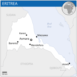
Eritrea (pronounced /ˌɛrɨˈtreɪ.ə/ (deprecatit template) or /ˌɛrɨˈtriːə/;[9] Ge'ez: ኤርትራ ʾErtrā, Arabic: إرتريا Iritrīyā), offeecially the State o Eritrea, is a kintra in the North East o Africae. The caipital is Asmara. It is bordered bi Sudan in the wast, Ethiopie in the sooth, an Djibouti in the sootheast. The east an northeast o the kintra hae an extensive coastline on the Red Sea, directly athort frae Saudi Arabie an Yemen. The Dahlak Archipelago an several o the Hanish Islands are pairt o Eritrea. Eritrea's size is approximately 117,600 km2 wi an estimatit population o 5 million.
References
[eedit | eedit soorce]- ↑ People and Languages » Embassy of The State of Eritrea Archived 2018-10-28 at the Wayback Machine. Eritrean-embassy.se. Retrieved on 5 June 2016.
- ↑ Ethnologue: Ethnologue Languages of the World – Eritrea – Status
- ↑ "Eritrea – Languages". Ethnologue. Retrieved 13 October 2016.
- ↑ a b c Shabait Administrator. "ERITREA AT A GLANCE". Eritrea Ministry of Information. Archived frae the original on 3 Mairch 2012. Retrieved 1 September 2017.
- ↑ CIA – Eritrea – Ethnic groups Archived 2019-01-06 at the Wayback Machine. Cia.gov. Retrieved 25 June 2012.
- ↑ Eritrea entry at The World Factbook
- ↑ a b c d "Eritrea". International Monetary Fund. Retrieved 1 October 2014.
- ↑ "Human Development Report 2016 – "Human Development for Everyone"" (PDF). HDRO (Human Development Report Office) United Nations Development Programme. Retrieved 22 Mairch 2017.
- ↑ "Merriam-Webster Online". Merriam-webster.com. 25 Apryle 2007. Retrieved 2 Mey 2010.
| Wikimedia Commons haes media relatit tae Eritrea. |


