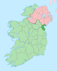
라우스주
보이기

라우스주(영어: County Louth [ˈlaʊð][*], 아일랜드어: Contae Lú, Lugmad, Lughbhadh, Lughbhaidh, Lughmhadh 콘테 루, 루그마드, 루그와그)는 아일랜드의 주로 주도는 던도크이며 면적은 826km2, 인구는 128,375명(2011년 기준)이다.
인구
[편집]| 연도 | 인구 | ±% |
|---|---|---|
| 1821 | 119,129 | — |
| 1831 | 124,846 | +4.8% |
| 1841 | 128,240 | +2.7% |
| 1851 | 107,662 | −16.0% |
| 1861 | 90,713 | −15.7% |
| 1871 | 84,021 | −7.4% |
| 1881 | 77,684 | −7.5% |
| 1891 | 71,038 | −8.6% |
| 1901 | 65,820 | −7.3% |
| 1911 | 63,665 | −3.3% |
| 1926 | 62,739 | −1.5% |
| 1936 | 64,339 | +2.6% |
| 1946 | 66,194 | +2.9% |
| 1951 | 68,771 | +3.9% |
| 1956 | 69,194 | +0.6% |
| 1961 | 67,378 | −2.6% |
| 1966 | 69,519 | +3.2% |
| 1971 | 74,951 | +7.8% |
| 1979 | 86,135 | +14.9% |
| 1981 | 88,514 | +2.8% |
| 1986 | 91,810 | +3.7% |
| 1991 | 90,724 | −1.2% |
| 1996 | 92,166 | +1.6% |
| 2002 | 101,821 | +10.5% |
| 2006 | 111,267 | +9.3% |
| 2011 | 122,897 | +10.5% |
| 2016 | 128,884 | +4.9% |
| [1][2][3][4][5][6][7] | ||
기후
[편집]| Ardee (1989–2019, extremes 1968–present), 31 mAOD의 기후 | |||||||||||||
|---|---|---|---|---|---|---|---|---|---|---|---|---|---|
| 월 | 1월 | 2월 | 3월 | 4월 | 5월 | 6월 | 7월 | 8월 | 9월 | 10월 | 11월 | 12월 | 연간 |
| 역대 최고 기온 °C (°F) | 14.7 (58.5) |
16.7 (62.1) |
21.5 (70.7) |
22.1 (71.8) |
27.2 (81.0) |
29.4 (84.9) |
30.9 (87.6) |
29.5 (85.1) |
27.1 (80.8) |
20.7 (69.3) |
17.6 (63.7) |
16.1 (61.0) |
30.9 (87.6) |
| 일평균 최고 기온 °C (°F) | 8.3 (46.9) |
8.9 (48.0) |
10.7 (51.3) |
13.3 (55.9) |
16.1 (61.0) |
19.0 (66.2) |
20.6 (69.1) |
20.2 (68.4) |
18.1 (64.6) |
14.5 (58.1) |
10.9 (51.6) |
8.6 (47.5) |
14.1 (57.4) |
| 일평균 최저 기온 °C (°F) | 1.9 (35.4) |
1.7 (35.1) |
2.5 (36.5) |
4.2 (39.6) |
6.6 (43.9) |
9.6 (49.3) |
11.4 (52.5) |
11.0 (51.8) |
9.2 (48.6) |
6.2 (43.2) |
3.7 (38.7) |
2.0 (35.6) |
5.8 (42.5) |
| 역대 최저 기온 °C (°F) | −15.2 (4.6) |
−11.1 (12.0) |
−8.4 (16.9) |
−5.4 (22.3) |
−3.2 (26.2) |
−1.5 (29.3) |
1.0 (33.8) |
−1.1 (30.0) |
−3.5 (25.7) |
−5.5 (22.1) |
−8.2 (17.2) |
−11.8 (10.8) |
−15.2 (4.6) |
| 평균 강수량 mm (인치) | 74.0 (2.91) |
57.8 (2.28) |
54.1 (2.13) |
53.8 (2.12) |
61.5 (2.42) |
66.2 (2.61) |
67.0 (2.64) |
70.3 (2.77) |
63.3 (2.49) |
84.4 (3.32) |
86.7 (3.41) |
76.1 (3.00) |
815.2 (32.1) |
| 평균 강수일수 (≥ 1.0 mm) | 16 | 12 | 12 | 11 | 12 | 11 | 12 | 11 | 11 | 13 | 14 | 14 | 149 |
| 출처: Met Éireann[8] | |||||||||||||
각주
[편집]- ↑ “Census 2016 Sapmap Area: County Louth”. Central Statistics Office. 2016. 2018년 7월 7일에 원본 문서에서 보존된 문서. 2017년 7월 21일에 확인함.
- ↑ For 1653 and 1659 figures from Civil Survey Census of those years, Paper of Mr Hardinge to Royal Irish Academy 14 March 1865.
- ↑ “Server Error 404 - CSO - Central Statistics Office”. 《www.cso.ie》. 2018년 3월 20일에 확인함.
- ↑ “HISTPOP.ORG - Home”. 《www.histpop.org》. 2016년 5월 7일에 원본 문서에서 보존된 문서.
- ↑ NISRA - Northern Ireland Statistics and Research Agency (c) 2013 보관됨 17 2월 2012 - 웨이백 머신. Nisranew.nisra.gov.uk (27 September 2010). Retrieved on 2013-07-23.
- ↑ Lee, JJ (1981). 〈On the accuracy of the Pre-famine Irish censuses〉. Goldstrom, J. M.; Clarkson, L. A. 《Irish Population, Economy, and Society: Essays in Honour of the Late K. H. Connell》. Oxford, England: Clarendon Press.
- ↑ Mokyr, Joel; O Grada, Cormac (November 1984). “New Developments in Irish Population History, 1700-1850”. 《The Economic History Review》 37 (4): 473–488. doi:10.1111/j.1468-0289.1984.tb00344.x. hdl:10197/1406. 2012년 12월 4일에 원본 문서에서 보존된 문서.
- ↑ “Ardee 1989-2019 Averages, Extremes 1968-”.
외부 링크
[편집] 위키미디어 공용에 라우스주 관련 미디어 분류가 있습니다.
| 이 글은 아일랜드에 관한 토막글입니다. 여러분의 지식으로 알차게 문서를 완성해 갑시다. |


