Somiedo
Appearance
Somiedo | |
|---|---|
 | |
 | |
| Coordinates: 43°6′N 6°15′W / 43.100°N 6.250°W | |
| Country | Spain |
| Autonomous community | Asturias |
| Province | Asturias |
| Comarca | Oviedo |
| Judicial district | Grado |
| Capital | Pola de Somiedo |
| Government | |
| • Alcalde | Belarmino Fernández Fervienza (PSOE) |
| Area | |
• Total | 291.38 km2 (112.50 sq mi) |
| Highest elevation | 2,194 m (7,198 ft) |
| Population (2018)[1] | |
• Total | 1,125 |
| • Density | 3.9/km2 (10.0/sq mi) |
| Demonym | somedano/a |
| Time zone | UTC+1 (CET) |
| • Summer (DST) | UTC+2 (CEST) |
| Postal code | 33840 - 3842 |
| Website | Official website |
You can help expand this article with text translated from the corresponding article in Spanish. (April 2009) Click [show] for important translation instructions.
|
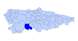
Somiedo (Asturian: Somiedu) is a municipality in the Autonomous Community of the Principality of Asturias, Spain. It is bordered on the north by Belmonte de Miranda, on the east by Teverga, on the west by Tineo and Cangas del Narcea, and on the south by the province of León.[2]
It is the second least densely populated municipality in Asturias.
All of the municipality forms part of Somiedo Natural Park, which has been declared a biosphere reserve by Unesco.[3]
Parishes
[edit]Politics
[edit]| PSOE | PP | CDS | Otros | Total | |
|---|---|---|---|---|---|
| 1979 | 6 | 4 | 1 | 0 | 11 |
| 1983 | 7 | 4 | - | 0 | 11 |
| 1987 | 7 | 4 | - | 0 | 11 |
| 1991 | 7 | 2 | - | 0 | 9 |
| 1995 | 5 | 4 | - | 0 | 9 |
| 1999 | 7 | 1 | - | 1 | 9 |
| 2003 | 8 | 1 | - | 0 | 9 |
| 2007 | 7 | 2 | - | 0 | 9 |
References
[edit]- ^ Municipal Register of Spain 2018. National Statistics Institute.
- ^ Menéndez, Carmen-Oliva (2008): Teitos. Cubiertas vegetales de Europa Occidental: de Asturias a Islandia. Colegio Oficial de Aparejadores y Arquitectos Técnicos del Principado de Asturias. ISBN 9788461276561
- ^ UNESCO: Somiedo Biosphere Reserve, Spain
External links
[edit]Wikimedia Commons has media related to Somiedo.
- Hiking routes in Somiedo (in English)
- Somiedo Natural Park (in Spanish)
- Federación Asturiana de Concejos (in Spanish)
- Estado del Embalse de Somiedo (in Spanish)


