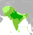
File:Map-Hindustani World.png
Appearance
Map-Hindustani_World.png (347 × 361 pixels, file size: 15 KB, MIME type: image/png)
File history
Click on a date/time to view the file as it appeared at that time.
| Date/Time | Thumbnail | Dimensions | User | Comment | |
|---|---|---|---|---|---|
| current | 23:33, 14 January 2023 |  | 347 × 361 (15 KB) | Kwamikagami | rm light green most countries -- even in Nepal it's only 8% |
| 11:41, 27 September 2020 |  | 347 × 361 (7 KB) | Rizorius | According to en:Languages of Afghanistan, %2-3 of Afghanistan population understand Hindi/Urdu, therefore it is not a widely understood language there. | |
| 00:42, 9 November 2017 |  | 347 × 361 (9 KB) | A2D2 | Urdu (the Hindustani variety in Pakistan) is not the mother language of the majority in the Sindh Province, and anywhere else in Pakistan. | |
| 04:36, 3 January 2014 |  | 347 × 361 (7 KB) | Fobos92 | . | |
| 04:54, 1 October 2008 |  | 192 × 215 (3 KB) | Samwingkit | {{Information |Description= Map of Hindi and Urdu Speaking World. * Dark green: Hindustani-speaking majority * Medium green: official language * Light green: Hindustani widely understood |Source=en:Image:Map-Hindustani World.png |Date=J |
File usage
No pages on the English Wikipedia use this file (pages on other projects are not listed).
Global file usage
The following other wikis use this file:
- Usage on ast.wikipedia.org
- Usage on el.wikipedia.org
- Usage on es.wikipedia.org
- Usage on fa.wikipedia.org
- Usage on gn.wikipedia.org
- Usage on it.wikiquote.org
- Usage on ja.wikipedia.org
- Usage on nl.wikipedia.org
- Usage on pt.wikipedia.org
- Usage on sw.wikipedia.org
- Usage on uk.wikipedia.org
- Usage on yo.wikipedia.org


