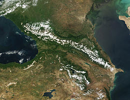
大高加索山脈
外观
| 大高加索山脈 | |
|---|---|
 位於卡拉恰伊-切爾克斯的雪山景觀 | |
 大高加索山脈(上)和小高加索山脈(下) | |
| 最高点 | |
| 山峰 | 厄爾布魯士峰 |
| 海拔 | 5,642米(18,510英尺) |
| 坐标 | 43°21′18″N 42°26′31″E / 43.35500°N 42.44194°E |
| 规模 | |
| 长度 | 1,200公里(750英里) |
| 地理 | |
| 国家 | |
| 所属山脉 | 高加索山脈 |
大高加索山脈(英语:Greater Caucasus)是高加索山脈中兩個主要山脈之一,與另一主要山脈小高加索山脈在蘇拉姆山脈相連後平行伸延,兩者平均相距100公里。大高加索山脈從黑海海岸的塔曼半島一直向東南方伸延至鄰近裡海的阿塞拜疆首都巴庫,全長約1,200公里,是亞美尼亞高原的北部和東北部邊緣,也成為俄羅斯、格魯吉亞和阿塞拜疆的邊界,最高峰是海拔高度5,642米的厄爾布魯士峰。大高加索山脈被分為三部份,包括:
歐洲和亞洲的邊界
[编辑]此高加索的分水嶺常被為是東歐和西亞的邊界,其中屬於分水嶺以北的歐洲部分被稱為前高加索,屬於分水嶺以南的亞洲部分則稱為外高加索。[1]
山峰
[编辑]- 厄爾布魯士峰(5642米),43°21′18″N 42°26′21″E / 43.35500°N 42.43917°E ,為歐洲最高的山峰。
- 德赫套山(5205米),43°3′N 43°8′E / 43.050°N 43.133°E
- 什哈拉山(5193米),43°01′N 43°10′E / 43.01°N 43.17°E
- 科什坦山(5151米),43°03′00″N 43°13′00″E / 43.05°N 43.2167°E
- 占吉山(5051米),43°01′08″N 43°03′24″E / 43.01889°N 43.05671°E
- 卡茲別克山(5047米),42°41′51″N 44°31′08″E / 42.69750°N 44.51889°E
參見
[编辑]
參考資料
[编辑]- ^ 18th-century definitions drew the boundary north of the Caucasus, across the Kuma–Manych Depression. This definition remained in use in the Soviet Union during the 20th century. In Western literature, the continental boundary has been drawn along the Caucasus watershed since at least the mid 19th century. See e.g. Baron von Haxthausen, "Transcaucasia" (1854); review Dublin university magazine (页面存档备份,存于互联网档案馆) Douglas W. Freshfield, "Journey in the Caucasus (页面存档备份,存于互联网档案馆)", Proceedings of the Royal Geographical Society, Volumes 13-14, 1869.

