iBet uBet web content aggregator. Adding the entire web to your favor.


Link to original content: http://www.bible-history.com/geography/israel-first-century
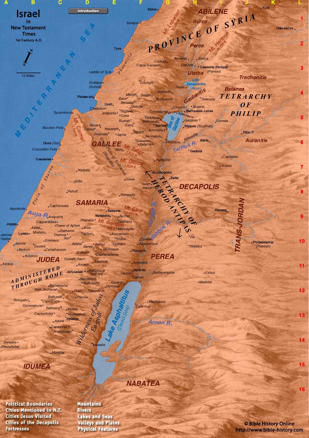
Map of New Testament Israel - Bible History

Map of New Testament Israel

First Century Israel

Map of Israel (First Century AD)

Sitemap

Nazareth

Introduction

Political Boundaries

New Testament Cities

Cities Jesus Visited

Cities of the Decapolis

Fortresses

Mountains

Rivers

Lakes and Seas

Valleys and Plains

Physical Features of the Holy Land

The Great Sea

The Coastal Plain

The Central Mountains Plateau

The Deep Jordan Valley

The Other Side of the Jordan

The Great Desert

Highways and Roads

The Rocky Hills

Jerusalem - Fashioned for a King

Geography Overview

How to Use This Program

Updates

Roman Provincial Organization

Glossary

Abelane

Abila of Abilene

Abila of Decapolis

Abilene

Accaron

Acchabare

Accrabbein

Adasa

Adida

Administered Through Rome

Adora

Aenon

Agrippina

Alexandrium

Alulos

Amasa

Ammathus

Anathoth

Antipatris

Appolonia

Arbela

Archelais

Arimathea

Aristobulias

Arnon River

Arus

Auja River

Auranitis

Azotus

Baca

Batanea

Beersheba

Beit Jibrin

Bemesilis

Berea

Bersabe

Besara

Beth bassi

Beth Zechariah

Bethany

Betharamptha

Bethel

Bethlehem

Bethletepha

Bethmaus

Bethphage

Bethsaida Julias

Bethzaith

Bethzur

Betogabri

Betshura

Bucolon Polis

Cadasa

Caesarea

Caesarea Philippi Paneas

Callirrhoe

Cana

Capar Ganaeoi

Caparorsa

Capernaum

Capharabis

Capharsaba

Capharsalama

Caphartobis

Capitolias

Capparetaea

Cariathiareim

Chabulon

Chinnereth

Chorazin

Coreae

Crocodilon Polis

Cyprus

Dabaritta

Dalmanutha

Damascus

Danos

Daphne

Dead Sea

Decapolis

Dion

Dora Dor

dotted

E. Syria

Ecdippa Achzib

Emmatha

Emmaus

En-Gedi

Ephraim

Esbus

Esdraelon

Etam

Gabae

Gabaon

Gabath Saul

Gadara

Galilee

Gamala

Gammaruris

Garis

Gaulanitis

Gazara

Gennesaret

Gerasa

Gergesa

Ginae

Gischala

Gitta

Hebron

Herod the Great and Political Boundaries

Herodium

Heshbon

Hill Country of Judea

Hippos Susithah

Hyrcania

Idumea

Ilon

Itabyrium

Iturea

Jabbok River

Jamneith

Jamnia

Jamnia Harbor

Japha

Jericho

Jerusalem

Joppa

Jordan River

Jotaparta

Judah

Judea

Kedron

Ladder of Tyre

Lake Asphaltitus (Dead Sea)

Lake Gennesaret

Lake of Gennesaret

Lake Semichonitis Huleh

Lower Galilee

Lydda

Machaerus

Magdala

Mahnayim

Malatba

Malatha

Map of the Near East in Abrahams Time

Masada

Medeba

Mediterranean Sea

Megiddo

Meroth

Michmash

Modein

Mount Carmel

Mount Ebal

Mount Gerizim

Mount Gilboa

Mount Hermon

Mount Lebanon

Mount Tabor

Nabatea

Nain

Narbata

Nazareth

Neapolis

Pella

Perea

Pharaton

Phasaelis

Philadelphia Rabbah

Philoteria

Phoenicia

Plain of Esdraelon Megiddo

Plain of Sharon

Pool of Bethesda

Province of Syria

Ptolemais

Qumran

Rathamin

Registered Version

Rumah

Saab

Salim

Samaria

Sarepta

Scythopolis

Sea of Galilee

Sea of Tiberias

Sebaste

Selame

Seleucia

Sennabris

Sepph

Sepphoris

Shiloh

Sidon

Sigoph

Simonias

Sogane

Sycaminum

Sychar

Taricheae

Taurus

Tephon

Terebinthus

Tetrarch

Tetrarchy of Herod Antipas

Tetrarchy of Philip

Thamna

Thecoa

Thella

Tiberias

Tirathana

Tower of Aphek

Trachonitis

TransJordan

Tyre

Ulatha

Upper Galilee

Valley of Jezreel

W. Syria

Wadi Qumran

Wilderness of Judea

Yarmuk River

Yishub

Zia

Old Testament Map of Israel

New Testament Map of Israel

Bible Maps