Zuidplas
Appearance
Zuidplas | |
|---|---|
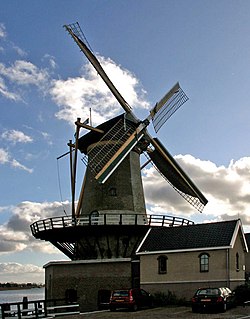
 Wind mill "Windlust" in Nieuwerkerk aan den IJssel | |
 Location in South Holland | |
| Coordinates: 51°58′N 4°37′E / 51.967°N 4.617°E | |
| Country | Netherlands |
| Province | South Holland |
| Established | 1 January 2010[1] |
| Government | |
| • Body | Municipal council |
| • Mayor | Gert-Jan Kats (SGP) |
| Area | |
• Total | 64.05 km2 (24.73 sq mi) |
| • Land | 58.02 km2 (22.40 sq mi) |
| • Water | 6.03 km2 (2.33 sq mi) |
| Elevation | −6 m (−20 ft) |
| Lowest elevation | −6.76 m (−22.18 ft) |
| Population (January 2021)[6] | |
• Total | 45,064 |
| • Density | 777/km2 (2,010/sq mi) |
| Time zone | UTC+1 (CET) |
| • Summer (DST) | UTC+2 (CEST) |
| Postcode | 2750–2761, 2840–2841, 2910–2914 |
| Area code | 0180, 0182, 079 |
| Website | www |
Zuidplas (Dutch pronunciation: [ˈzœytplɑs]) is a municipality in the Netherlands located in the province of South Holland. It was established on 1 January 2010 by the joining of Moordrecht, Nieuwerkerk aan den IJssel, and Zevenhuizen-Moerkapelle. It had a population of 41,753 as of August 2017.
Topography
[edit]Dutch Topographic map of the municipality of Zuidplas, September 2014
Notable people
[edit]
- Claes Michielsz Bontenbal (1575–1623) Secretary of Zevenhuizen and conspirator
- Lia van Rhijn (born 1953) ceramist and sculptor
- Arie Slob (born 1961) politician and history teacher
- Angela Visser (born 1966) actress, model and beauty queen, Miss Universe 1989[7]
- Hans Spekman (born 1966) politician
- Dirk Bruinenberg (born 1968) musician, former drummer of metal and power metal bands
- Tamara van Ark (born 1974) politician and minister
Sport
[edit]
- Jan Bazen (born 1948) former speed skater, competed at the 1976 Winter Olympics
- Brecht Rodenburg (born 1967) retired volleyball player, team gold medallist at the 1996 Summer Olympics
- Sjoert Brink (born 1981) professional bridge player
- Lars Elgersma (born 1983) short and middle distance speed skater
- Ronald Hertog (born 1989) amputee and Paralympic javelin thrower, flag-bearer at the 2012 Summer Paralympics
- Raymond Kreder (born 1989) professional road racing cyclist
- Bastiaan Lijesen (born 1990) swimmer, competed at the 2012 Summer Olympics
- Memphis Depay (born 1994) professional footballer, over 200 club caps
References
[edit]- ^ "Gemeentelijke indeling op 1 januari 2010" [Municipal divisions on 1 January 2010]. cbs.nl (in Dutch). CBS. Retrieved 31 August 2013.
- ^ "College van B&W" [Board of mayor and aldermen] (in Dutch). Gemeente Zuidplas. Retrieved 31 August 2013.
- ^ "Kerncijfers wijken en buurten 2020" [Key figures for neighbourhoods 2020]. StatLine (in Dutch). CBS. 24 July 2020. Retrieved 19 September 2020.
- ^ "Postcodetool for 2914KM". Actueel Hoogtebestand Nederland (in Dutch). Het Waterschapshuis. Retrieved 31 August 2013.
- ^ "Laagste punt van Nederland" [Lowest point of the Netherlands] (in Dutch). Gemeente Zuidplas. Retrieved 31 August 2013.
- ^ "Bevolkingsontwikkeling; regio per maand" [Population growth; regions per month]. CBS Statline (in Dutch). CBS. 1 January 2021. Retrieved 2 January 2022.
- ^ IMDb Database retrieved 2 May 2019


