South Holland District
South Holland District | |
|---|---|
| |
 Shown within the ceremonial county of Lincolnshire | |
| Sovereign state | United Kingdom |
| Constituent country | England |
| Region | East Midlands |
| Administrative county | Lincolnshire |
| Admin. HQ | Spalding |
| Government | |
| • Type | South Holland District Council |
| • Leadership: | Leader & Cabinet |
| • Executive: | Conservative |
| • MP: | John Hayes |
| Area | |
• Total | 290 sq mi (750 km2) |
| • Rank | 44th |
| Population (2022) | |
• Total | 96,983 |
| • Rank | Ranked 249th |
| • Density | 330/sq mi (130/km2) |
| Ethnicity (2021) | |
| • Ethnic groups | |
| Religion (2021) | |
| • Religion | List
|
| Time zone | UTC+0 (Greenwich Mean Time) |
| • Summer (DST) | UTC+1 (British Summer Time) |
| ONS code | 32UF (ONS) E07000140 (GSS) |
South Holland District Council | |
|---|---|
 | |
| Type | |
| Type | |
| Leadership | |
Rob Barlow since October 2021[3] | |
| Structure | |
| Seats | 37[4] |
Political groups | Administration (20)
Other parties (17)
|
| Elections | |
Last election | 4 May 2023 |
Next election | 2027 |
| Meeting place | |
 | |
| Council Offices, Priory Road, Spalding, PE11 2XE | |
| Website | |
| www | |
South Holland is a local government district of Lincolnshire, England. The council is based in Spalding. Other notable towns and villages include Crowland, Sutton Bridge, Donington, Holbeach and Long Sutton. The district is named after the historical division of Lincolnshire known as the Parts of Holland.
The neighbouring districts are Boston, North Kesteven, South Kesteven, Peterborough, Fenland and King's Lynn and West Norfolk.
History
[edit]The district was formed on 1 April 1974 under the Local Government Act 1972. It covered the area of three former districts from the administrative county of Holland, which were all abolished at the same time:[5]
The new district was named South Holland referencing its position within Holland, one of the three historic parts of Lincolnshire.[6]
In 2021 the district council joined East Lindsey District Council and Boston Borough Council in the "South and East Lincolnshire Councils Partnership" which shares management and other staff.[7]
Governance
[edit]South Holland District Council provides district-level services. County-level services are provided by Lincolnshire County Council.[8] Much of the district is also covered by civil parishes, which form a third tier of local government. The town of Spalding is an unparished area.[9]
Political control
[edit]The council has been under Conservative majority control since 2003.
The first election to the council was held in 1973, initially operating as a shadow authority alongside the outgoing authorities until the new arrangements came into effect on 1 April 1974. Political control of the council since 1974 has been as follows:[10]
| Party in control | Years | |
|---|---|---|
| Independent | 1974–1987 | |
| No overall control | 1987–1991 | |
| Independent | 1991–1997 | |
| No overall control | 1997–1999 | |
| Conservative | 1999–2002 | |
| No overall control | 2002–2003 | |
| Conservative | 2003–present | |
Leadership
[edit]The leaders of the council since 2003 have been:[11]
| Councillor | Party | From | To | |
|---|---|---|---|---|
| Gary Porter[12] | Conservative | 2003 | 7 May 2023 | |
| Nick Worth | Conservative | 17 May 2023 | ||
Composition
[edit]Following the 2023 election and a by-election in November 2023, the composition of the council was:[13][14]
| Party | Councillors | |
|---|---|---|
| Conservative | 20 | |
| South Holland Independents | 14 | |
| Independent | 3 | |
| Total | 37 | |
The South Holland Independents and independent councillors sit together as the "Independent Group".[15] The next election is due in 2027.
Premises
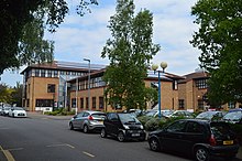
[edit]The council is based at the Council Offices on Priory Road in Spalding. The original building had been completed in 1954 for the Spalding Rural District Council, one of the modern council's predecessors.[16] A large extension was added in front of the original building in 1991.[17]
Elections
[edit]Since the last boundary changes in 2007 the council has comprised 37 councillors representing 18 wards, with each ward electing one, two or three councillors. Elections are held every four years.[18]
Landmarks from top left to bottom right:
- Trinity Bridge
- Crowland Abbey
- Crosskeys Bridge, Sutton Bridge
- Spalding Parish Church
- Sessions House, Spalding
- Ayscoughfee Hall, Spalding
- Skyline of Deeping St Nicholas in the Deepings
- Holbeach
- Long Sutton
Demographics
[edit]There were 76,512 residents in the district at the 2001 census.[19] The median age was nearly 43.[19] 82.6% of people in the district claimed to adhere to a Christian religion – the highest proportion of any district in the East Midlands.
The 2011 census reports 88,270 people at 1.2 per hectare in 37,264 households.[20]
Much of the district is low-lying and highly fertile agricultural land which is protected from flooding by land drainage. This is the responsibility of the South Holland Internal Drainage Board and the Environment Agency.[21]
Media
[edit]In terms of television, the area is served by BBC Yorkshire and Lincolnshire and ITV Yorkshire broadcast from the Belmont transmitter.[22] BBC East Midlands and ITV Central can also be received from the Waltham TV transmitter.[23] With the co-channel interference from the Waltham transmitter, a small number of households in the southern tip of the district are able to receive BBC East and ITV Anglia.[24]
Radio stations for the area are: [25]
- BBC Radio Lincolnshire on 104.7 FM and 94.9 FM
- BBC Radio Cambridgeshire can also be received on 95.7 FM,
- Lincs FM on DAB
- Greatest Hits Radio Lincolnshire on 96.7FM and 102.2 FM
- Connect Radio on 106.8 FM
- Heart Peterborough on 102.7 FM
- Tulip Radio (for Spalding) on 107.5 FM
Arms
[edit]
|
References
[edit]- ^ a b UK Census (2021). "2021 Census Area Profile – South Holland Local Authority (E07000140)". Nomis. Office for National Statistics. Retrieved 5 January 2024.
- ^ Browne, Duncan (23 May 2023). "New South Holland District Council leader Coun Nick Worth lays out his plans for the future and calls on teamwork from both sides of the chamber". Spalding Today. Retrieved 29 June 2023.
- ^ Brookes, Andrew (12 October 2021). "New South Holland District Council chief reveals ambitions to boost area". Spalding Today. Retrieved 29 June 2023.
- ^ "Councillors by party". South Holland District Council. Retrieved 1 April 2022.
- ^ "The English Non-metropolitan Districts (Definition) Order 1972", legislation.gov.uk, The National Archives, SI 1972/2039, retrieved 29 June 2023
- ^ "The English Non-metropolitan Districts (Names) Order 1973", legislation.gov.uk, The National Archives, SI 1973/551, retrieved 29 June 2023
- ^ "South and East Lincolnshire Councils Partnership". Boston Borough Council. Retrieved 23 November 2023.
- ^ "Local Government Act 1972", legislation.gov.uk, The National Archives, 1972 c. 70, retrieved 31 May 2023
- ^ "Election maps". Ordnance Survey. Retrieved 6 June 2023.
- ^ "Compositions calculator". The Elections Centre. 4 March 2016. Retrieved 1 June 2023.
- ^ "Council minutes". South Holland District Council. Retrieved 10 August 2022.
- ^ "Lord Gary Porter CBE". gov.uk. Retrieved 1 April 2022.
- ^ "Local elections 2023: live council results for England". The Guardian.
- ^ Fear, Victoria (28 November 2023). "Conservative Party re-takes Spalding St Paul's ward seat with Glynis Scalese winning the seat after the drawing of lots to decide tied race". Spalding Today. Retrieved 28 November 2023.
- ^ "Your councillors by political grouping". South Holland District Council. Retrieved 29 June 2023.
- ^ "Opening of council's new offices this week". Lincolnshire Free Press. Spalding. 20 April 1954. p. 1. Retrieved 29 June 2023.
- ^ "New offices mean better deal for you". Lincolnshire Free Press. Spalding. 29 October 1991. p. 9. Retrieved 29 June 2023.
- ^ "The District of South Holland (Electoral Changes) Order 2007", legislation.gov.uk, The National Archives, SI 2007/145, retrieved 29 June 2023
- ^ a b "District Council's summary of 2001 census results" (PDF).
- ^ "South Holland:Key Statistics". 2011 census. Office for National Statistics. Retrieved 20 April 2013.
- ^ "South Holland IDB". Water Management Alliance. Retrieved 12 June 2013.
- ^ "Belmont (Lincolnshire, England) Full Freeview transmitter". UK Free TV. 1 May 2004. Retrieved 19 April 2024.
- ^ "Full Freeview on the Waltham (Leicestershire, England) transmitter". UK Free TV. 1 May 2004. Retrieved 19 April 2024.
- ^ "Full Freeview on the Sandy Heath (Central Bedfordshire, England) transmitter". UK Free TV. 1 May 2004. Retrieved 19 April 2024.
- ^ "Radio Lincolnshire – Find Your Local Station". Lincolnshire.org. Retrieved 19 April 2024.
- ^ "East Midlands Region". Civic Heraldry of England. Retrieved 8 March 2021.


