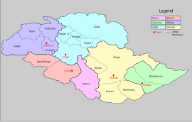
Gupis Tehsil

Gupis Tehsil is an administrative division (a tehsil) of Gupis-Yasin District, in Gilgit-Baltistan, a northern region of Pakistan.[1] Gupis Tehsil lies in the southern part of the district. There are many villages and lush green and very pleasant places[2] and resort and historical places like Yangal, Sumal, Hakis, Jindrote, Dahimal, Pingal and Khasunder.[3]
Phander
[edit]This area Of Gupis-Yasin District is located in Shandur Pass which joins Chitral and Gilgit Baltistan. It also can be a path to join Tajikistan and Pakistan.
Phander Valley is well known for trout fish found in abundance. Phander includes Shamaran, Chachi, Dalimal, Gulagmuli, and Teru villages.
This area has a lake which abounds in trout. It is about 170 km from Gilgit city and the time required to get there is about 5 hours.[clarification needed]
Shandur Pass
[edit]This is a 12,500 feet high pass which connects Gilgit to Chitral. The pass remains snow-bound during winters. It is 250 km and 15 hours away by jeep.[clarification needed]
Administration
[edit]The Gupis tehsil is administratively divided into many Union Councils.[weasel words]
References
[edit]- ^ "Khalti Lake, Gupis | Gilgit Baltistan - promoting culture and tourism". gilgit-baltistan.com. Archived from the original on 2020-07-02. Retrieved 2016-01-25.
- ^ "Explore Gupis, Gilgit Baltistan | Destination Pakistan". destinationpak.com. Retrieved 2016-01-25.
- ^ "Avalanche Hit Village, Gupis Tehsil of Ghizar". Dardistan Times. 30 April 2009. Retrieved 2016-01-25.

