Coppergate
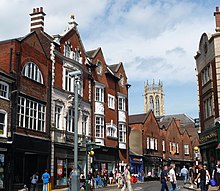
 Looking north-east on Coppergate | |
 Location within York | |
| Former name(s) |
|
|---|---|
| Location | York, England |
| Coordinates | 53°57′28″N 1°04′51″W / 53.9579°N 1.0808°W |
| North east end | |
| South west end |
|
Coppergate is a street in the city centre of York, in England. The street runs north-east from the junction of Castlegate, Nessgate, King Street and Clifford Street, to end at the junction of Pavement, Piccadilly, Parliament Street, and High Ousegate.[1]
History
[edit]The site of the street lays outside Roman York's walls and was a glass-making district.[2] It was abandoned after the Roman period and re-occupied during the 9th-century, Viking York. During the 11th-century, housing existed on the street, found through archaeological finding.[3][1]
Some time between 1120 and 1135, it was first recorded as a centre for coopers, from which its name derives.[1] Over time, the Pavement Market spread onto the street.[4] The south-western end of the street was widened in 1900, leading to the replacement of most Mediaeval buildings.[1]
In 1976, major Viking remains were found immediately south of the street, while a cinema and the Cravens confectionery factory were demolished. Coppergate Shopping Centre opened in 1984, over the demolished buildings.[3][5]
Architecture
[edit]
The back of the church of All Saints, Pavement, lies on the north side of the street, followed by a row of shops with their main entrances on High Ousegate. Numbers 3–7 was built in two stages in the 1900s, and in the late-20th century was occupied by Habitat. On the south side, Galtres Chambers and the 16th-century Three Tuns pub are both listed buildings, as are two structures with 15th-century origins: 26 Coppergate, and 28–32 Coppergate.[1][6]
References
[edit]- ^ a b c d e An Inventory of the Historical Monuments in City of York, Volume 5, Central. London: HMSO. 1981. Retrieved 7 August 2020.
- ^ Hall, Richard (1996). English Heritage: Book of York. B. T. Batsford. p. 31. ISBN 0713477202.
- ^ a b "Character Area Twelve: King's Staith & Coppergate Centre". City of York Council. Retrieved 12 August 2020.
- ^ A History of the County of York: the City of York. London: Victoria County History. 1961. Retrieved 12 August 2020.
- ^ "Records from Cravens add missing ingredient to York's sweet story". University of York. 31 January 2020. Retrieved 15 June 2021.
- ^ Pevsner, Nikolaus (1995). Yorkshire: York and the East Riding. Yale University Press. p. 215. ISBN 0300095937.

