Historic Bridgetown and its Garrison
Historic Bridgetown and its Garrison
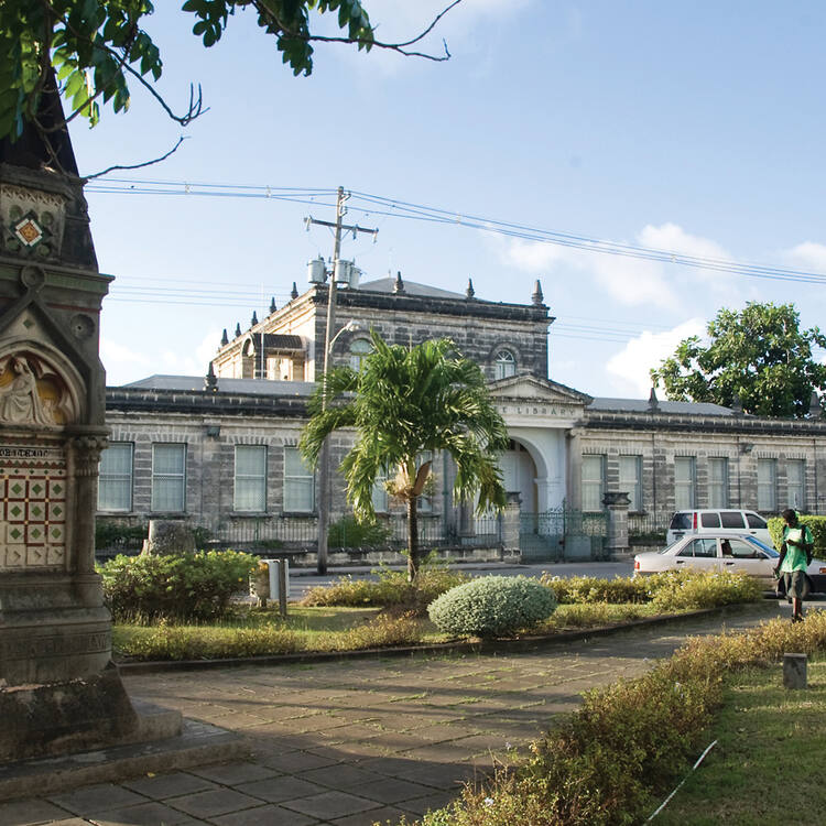
Historic Bridgetown and its Garrison, an outstanding example of British colonial architecture consisting of a well-preserved old town built in the 17th, 18th and 19th centuries, which testifies to the spread of Great Britain's Atlantic colonial empire. The property also includes a nearby military garrison which consists of numerous historic buildings. With its serpentine urban lay-out the property testifies to a different approach to colonial town-planning compared to the Spanish and Dutch colonial cities of the region which were built along a grid plan.
Description is available under license CC-BY-SA IGO 3.0
Centre historique de Bridgetown et sa garnison
Le centre historique de Brigdgetown et sa garnison est un exemple exceptionnel de l'architecture coloniale britannique qui consiste en une vieille ville construite aux XVIIe, XVIIIe et XIXe siècle, qui témoigne de l'expansion de l'empire colonial britannique dans la zone atlantique. Le bien comprend également une garnison militaire située à proximité et composée de nombreux bâtiments historiques. Avec sa configuration de rues sinueuses, le bien témoigne d'une approche distincte des villes coloniales créées par les Espagnols ou les Néerlandais selon un plan en damier.
Description is available under license CC-BY-SA IGO 3.0
بريدجتاون التاريخية وحاميتها
من الأمثلة البارزة على العمارة الاستعمارية البريطانية التي تتكون من مدينة قديمة محمية جيدًا بنيت خلال القرون السابع عشر والثامن عشر والتاسع عشر، والتي تدل إلى انتشار استعمار بريطانيا العظمى لمنطقة الأطلسي. وتشمل المواقع أيضًا حامية عسكرية تتكون من مبان تاريخية كثيرة. واعتمادًا على شوارعها المتعرجة والمتداخلة، يشهد الموقع مقاربات متنوعة للتنظيم المدني الاستعماري، مقارنة بالمستعمرات الإسبانية والهولندية في المنطقة التي بنيت وفق تصميم هندسي مشبك.
source: UNESCO/CPE
Description is available under license CC-BY-SA IGO 3.0
布里奇顿及其军事要塞
由一组建于17-19世纪、保存完好的老城镇所构成,是英国殖民地建筑的典范之作,也是大不列颠在大西洋进行殖民帝国扩张的见证。这一遗产还包括附近一处由许多历史性建筑物组成的军事要塞。此处的城镇所采取的蛇形城市布局,有别于西班牙及荷兰在此处的殖民城镇所采取的井字形布局建设方式,展现了殖民地城镇规划所采用的不同方式。
source: UNESCO/CPE
Description is available under license CC-BY-SA IGO 3.0
Исторический Бриджтаун с его военными укреплениями
замечательный образец британской колониальной архитектуры, включающий хорошо сохранившийся старый город, построенный на протяжении 17-19 столетий, свидетельствует о размерах колониальной империи Великобритании в Атлантике. Частью объекта является близлежащий военный городок, состоящий из многих строений, имеющих историческое значение. Его вьющаяся серпантином планировка демонстрирует иной подход к колониальной городской застройке, чем испанские и голландские колониальные поселения в том же регионе, выстроенные по сетевой схеме.
source: UNESCO/CPE
Description is available under license CC-BY-SA IGO 3.0
El Centro histórico de Bridgetown y su guarnición militar
Es un ejemplo sobresaliente de la arquitectura colonial británica. Consiste en una ciudad antigua bien preservada, construida en los siglos XVII, XVIII y XIX, que atestigua el desarrollo del imperio colonial atlántico de Gran Bretaña. El sitio incluye también una guarnición militar cercana con numerosos edificios históricos. La distribución de las calles de la ciudad, en forma de serpentina, muestra una forma de planeamiento urbano diferente a la de otras ciudades coloniales de la región construidas por los españoles y los holandeses, que responden a planos ortogonales.
source: UNESCO/CPE
Description is available under license CC-BY-SA IGO 3.0
ブリッジタウン歴史地区とその要塞
ブリッジタウン歴史地区とその要塞は、17世紀から19世紀にかけて建てられた保存状態の良い古い街を含む英国植民地建築の代表例であり、大英帝国の大西洋における植民地支配が拡大したことを例証する。 この遺跡は、数多くの歴史的建造物から成る、隣接する要塞も含んでいる。曲がりくねった形状を持つこの都市は、格子状に建設されたスペインやオランダの植民地都市とは異なった都市計画に基づくことを示している。source: NFUAJ
Historisch Bridgetown en garnizoen
Het historische Bridgetown en haar Garnizoen zijn een mooi voorbeeld van koloniale architectuur. De goed bewaard gebleven oude stad - gebouwd in de 17e, 18e en 19 eeuw - getuigt van het uitbreidende Atlantische koloniale rijk van Groot Brittannië. De versterkte havenstad werd het middelpunt van de Britse handel in Zuid-Amerika als opslagplaats voor goederen en tot slaaf gemaakte personen. Er is ook een militair garnizoen bestaand uit een groot aantal historische gebouwen. Het gebied heeft een kronkelig stadsontwerp waarmee een andere benadering van koloniale stedenbouw zichtbaar wordt aangezien de Spaanse en Nederlandse koloniale steden in de regio gebouwd werden volgens een rasterpatroon.
Source: unesco.nl
Outstanding Universal Value
Brief Synthesis
As one of the earliest established towns with a fortified port in the Caribbean network of military and maritime-mercantile outposts of the British Atlantic, Historic Bridgetown and its Garrison was the focus of trade-based English expansion in the Americas. By the 17th century, the fortified port town was able to establish its importance in the British Atlantic trade and became an entrepôt for goods, especially sugar, and enslaved persons destined for Barbados and the rest of the Americas.
Historic Bridgetown’s irregular settlement patterns and 17th Century street layout of an English medieval type, in particular the organic serpentine streets, supported the development and transformation of creolized forms of architecture, including Caribbean Georgian.
Historic Bridgetown’s fortified port spaces were linked along the Bay Street corridor from the historic town’s centre to St. Ann’s Garrison. The property’s natural harbour, Carlisle Bay, was the first port of call on the trans-Atlantic crossing and was perfectly positioned as the launching point for the projection of British imperial power, to defend and expand Britain’s trade interests in the region and the Atlantic World. Used as a base for amphibious command and control, the garrison housed the Eastern Caribbean headquarters of the British Army and Navy. Historic Bridgetown and its Garrison participated not only in the international trade of goods and enslaved persons but also in the transmission of ideas and cultures that characterized the developing colonial enterprise in the Atlantic World.
Criterion (ii): Historic Bridgetown and its Garrison had a pivotal role in the development of the English colonies in the Atlantic World and was a centre for transmission of ideas concerning administration, trade, communications, science, culture and technology in the British Empire. While the Garrison can be said to have absorbed military ideas from Europe and transmitted them to other areas of the Caribbean, the social stratification of Bridgetown illustrates the interchange of several occupational, religious, ethnic, free and enslaved groups; a meeting of cultures, which created a hybridized Creole culture in the Anglophone Caribbean. This hybridized culture, which did not wholly abandon either European or African ways, lives on in the ways in which the urban space functions today.
Criterion (iii): Historic Bridgetown and its Garrison is an exceptional testimony of British colonial trade and defence in the Caribbean and the Americas. The historic town has retained its original footprint, based on its English medieval serpentine street layout, for almost 400 years, which bears exceptional testimony to British town layouts in foreign soil. St. Ann’s Garrison and its fortifications, which protected the town and its port, constitute the most complete complex of a 18th-19th century British garrison ensemble in the Atlantic World. As an integrated semi-planned urban landscape, with a strong brick architectural testimony, and a collection of colonial warehouses and dock facilities, it has remained essentially unchanged for 200 years, and provides an outstanding glimpse into a pivotal period of British imperial rule and culture.
Criterion (iv): St Ann’s Garrison is the earliest type of British navy and army base in the Caribbean and in its architectural layout and urban composition influenced later British presence in the region. The relation between the Historic Bridgetown and its Garrison is characterized by urban and architectural elements, which illustrate the continuous interaction between the commercial and military interests that dominated the evolution of functions in the colonial and post-colonial space. This is most evident in the tension between military order and economic resourcefulness, expressed among other by the Screw Dock, an outstanding but highly vulnerable structure, and the 18th and 19th century warehouses, built to withstand hurricanes and other threats in the tropical environment.
Integrity
The property covers the area that reflects the layout of the early town and port in Bridgetown and the overall Garrison, with all its historic components. These two elements are linked by a narrow strip along Bay Street, which creates the urban relation between the garrison, the city and the port. Within Bridgetown, the early 17th century path and road network still forms the basis of the organic street layout. The port area has been altered but provides traces to its historic use. The Garrison has retained a high percentage of its physical attributes, with exception of the naval dockyard, representing a significant era of British colonial military heritage. The basic road network of the garrison has not changed and also its boundary wall remains largely intact, with entrances to the site remaining in their original locations.
Authenticity
Bridgetown’s early serpentine street and alley configuration and also the roads in the Garrison retain their authentic networks. Both layouts continue in spite of the town’s transformation from a maritime-mercantile fortified port town to a contemporary cosmopolitan tropical city which has remained the island’s capital and national centre. Although several historic houses in Bridgetown have been replaced or restored, a significant number of remaining historic houses, some rapidly decaying, significantly contribute to the atmosphere of a historic city and should be conserved.
Within the Garrison, the main individual barracks and administrative buildings retain a high degree of authenticity and continue to provide similar functions as they did during the colonial era. Yet, the degree to which the overall garrison can convey its meaning in terms of former function is vulnerable and requires constant protection.
Protection and management requirements
Legal protection is provided by the Town and Country Planning Act, supported by the Physical Development Plan Amended (2003). The Physical Development Plan makes provision for five conservation areas covering different parts of Historic Bridgetown and its Garrison. While at present these planning provisions are technically adequate, legal protection of those parts of the property not covered by the conservation areas could be strengthened.
The highest level of policy decision-making for Historic Bridgetown and its Garrison is public sector-led through the Cabinet of the Government of Barbados, which holds ultimate responsibility for the management of the property. Management authority has been formally conferred on the Barbados World Heritage Committee. Through a coordinative function of this Committee, the management is shared among the respective responsible government agencies and also involves the collaborative effort of several non-governmental organizations and civil society, including a number of property owners.
The management plan, which was formally adopted by the Barbados Cabinet in 2011, defines that the Barbados World Heritage Committee forms the central plank in the administration of the property and oversees adherence to the principles of the Convention. It advises on policies and programmes for the conservation and management of the property, evaluates and monitors all matters relating to the protection and management of the property and, most importantly, continues to ensure that the management systems maintain and preserve the Outstanding Universal Value of the property.
The Chief Town Planner has been identified as the Site Manager for day-to-day management concerns in the framework of the urban development plan and planning permission procedures. He also chairs the Barbados World Heritage Committee which meets on a two-monthly basis. Thematic subcommittees meeting at shorter intervals are dedicated to specific areas of management, including education and capacity building, conservation of architectural heritage, interpretation and tourism management. Further work, as defined in the action plan, is required to strengthen the protection of the substance of remaining historic buildings and the property’s overall spatial layout, and also to mitigate landscape changes that have already occurred in order to protect and strengthen the property’s integrity and authenticity.


