South Jeolla Province
South Jeolla Province
전라남도 | |
|---|---|
| Korean transcription(s) | |
| • Hangul | 전라남도 |
| • Hanja | 全羅南道 |
| • McCune‑Reischauer | Chŏllanam-do |
| • Revised Romanization | Jeollanam-do |
 | |
| Coordinates: 34°45′N 127°0′E / 34.750°N 127.000°E | |
| Country | South Korea |
| Region | Honam |
| Capital | Muan County |
| Subdivisions | 5 cities; 17 counties |
| Government | |
| • Governor | Kim Yung-rok (Democratic) |
| Area | |
| • Total | 12,247 km2 (4,729 sq mi) |
| • Rank | 3rd |
| Population (October, 2014)[1] | |
| • Total | 1,902,324 |
| • Rank | 6th |
| • Density | 142/km2 (370/sq mi) |
| Metropolitan Symbols | |
| • Flower | Camellia japonica |
| • Tree | Ginkgo |
| • Bird | Oriental turtle dove |
| ISO 3166 code | KR-46 |
| Dialect | Jeolla |
| Website | Official website (English) |
South Jeolla Province, or Jeollanam-do (hangul: 전라남도; hanja: 全羅南道; McCune-Reischauer: Chŏllanam-do; Revised Romanization: Jeollanam-do), is a province in the southwest of South Korea.
The province keeps partnerships with many cities and provinces around the world.[2]
History
[change | change source]The South Jeolla province was formed in 1896 from the southern half of the former Jeolla province, remained a province of Korea until the country's division in 1945, then became part of South Korea. Gwangju was the capital of the province, until the provincial office moved to the southern village of Namak, Muan County in 2005.
Symbols of the province
[change | change source]The symbols of the province are:[3]
- Tree: Ginkgo - 은행나무 (Ginkgo biloba)
- Flower: Japanese camellia - 동백나무 (Camellia japonica)
- Bird: Oriental Turtle Dove - 멧비둘기 (Streptopelia orientalis)
- Fish: Red seabream - 참돔 (Pagrus major)
Geography
[change | change source]
The province is part of the Honam region, and is bounded on the west by the Yellow Sea, on the north by Jeollabukdo province, on the south by Jeju Strait, and on the east by Gyeongsangnam-do province
The province has an area of 12,256.9 square kilometres (4,732 square miles)[4] with a population, as for 2010, of 1,9404,55[1] and a density of 158.3 inhabitants per km².
There are almost 2,000 islands along the coastline, about three quarters of which are uninhabited. The coastline is about 6,400 kilometres (4,000 miles) long. Some of the marine products, in particular oyster and seaweed cultivation, are leading in South Korea.
The rivers Somjin, Tamjin and Yeongsam form plains that are very good for growing rice. The largest river is the Yeongsan, 115 kilometres (71 miles) long; it flows to the southwest and forms a estuary in the Yellow Sea at Mokpo.
Climate
[change | change source]In coastal areas, the climate is mild and humid, with annual rainfall of 1,289 millimetres (50.7 inches) and average temperatures of 13–14 degrees Celsius (55–57 degrees Fahrenheit). Summer is wet, windy and dry winter. The west side of the Sobaek mountains receives heavy snowfall.[5]
Administrative divisions
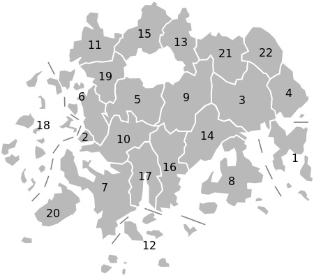
[change | change source]Jeollanam-do is divided into 5 cities (si) and 17 counties (gun). Listed below is the name of each entity in English, hangul, and hanja.
| Map | # | Name | Hangul | Hanja | Population (2012)[6] |
|---|---|---|---|---|---|

| |||||
| — City — | |||||
| 1 | Yeosu | 여수시 | 麗水市 | 296,479 | |
| 2 | Mokpo | 목포시 | 木浦市 | 247,207 | |
| 3 | Suncheon | 순천시 | 順天市 | 270,274 | |
| 4 | Gwangyang | 광양시 | 光陽市 | 144,129 | |
| 5 | Naju | 나주시 | 羅州市 | 93,237 | |
| — County — | |||||
| 6 | Muan | 무안군 | 務安郡 | 71,294 | |
| 7 | Haenam | 해남군 | 海南郡 | 81 321 | |
| 8 | Goheung | 고흥군 | 高興郡 | 76,118 | |
| 9 | Hwasun | 화순군 | 和順郡 | 70,757 | |
| 10 | Yeongam | 영암군 | 靈巖郡 | 64,596 | |
| 11 | Yeonggwang | 영광군 | 靈光郡 | 58,026 | |
| 12 | Wando | 완도군 | 莞島郡 | 54 867 | |
| 13 | Damyang | 담양군 | 潭陽郡 | 48,329 | |
| 14 | Boseong | 보성군 | 寶城郡 | 49,940 | |
| 15 | Jangseong | 장성군 | 長城郡 | 47,231 | |
| 16 | Jangheung | 장흥군 | 長興郡 | 42,643 | |
| 17 | Gangjin | 강진군 | 康津郡 | 41,160 | |
| 18 | Sinan | 신안군 | 新安郡 | 46,007 | |
| 19 | Hampyeong | 함평군 | 咸平郡 | 37,528 | |
| 20 | Jindo | 진도군 | 珍島郡 | 34,486 | |
| 21 | Gokseong | 곡성군 | 谷城郡 | 32,896 | |
| 22 | Gurye | 구례군 | 求禮郡 | 27,765 | |
References
[change | change source]- ↑ 1.0 1.1 "Population". JeollaNamdo, The Land of Green. Retrieved 12 September 2013.
- ↑ "International Exchanges". JeollaNamdo, The Land of Green. Retrieved 12 August 2013.
- ↑ "Symbols of JeollaNamdo". JeollaNamdo, The Land of Green. Retrieved 12 September 2013.
- ↑ "Administrative Districts". JeollaNamdo, The Land of Green. Retrieved 12 September 2013.
- ↑ "Climate". JeollaNamdo, The Land of Green. Retrieved 12 September 2013.
- ↑ "Demographic Statistics". JeollaNamdo, The Land of Green. Retrieved 12 August 2013.
Other websites
[change | change source]- Jeollanam-do provincial government English-language home page Archived 2016-10-15 at the Wayback Machine
- Office of Tourism of South Jeolla Archived 2011-11-09 at the Wayback Machine (in English, Japanese, Korean, and Chinese)
- Official Korea Tourism Organization: Jeollanam-do Archived 2013-08-14 at the Wayback Machine
- lonely planet: Introducing Jeollanam-do


