Maranhão
Appearance
State of Maranhão | |
|---|---|
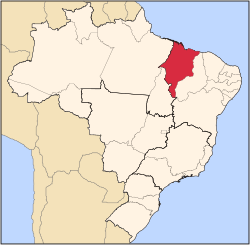
 Location of State of Maranhão in Brazil | |
| Coordinates: 6°11′S 45°37′W / 6.183°S 45.617°W | |
| Country | |
| Capital and Largest City | São Luís |
| Government | |
| • Governor | Flávio Dino (PSB) |
| • Vice Governor | Carlos Brandão (PSDB) |
| • Senators | Eliziane Gama (Cidadania) Roberto Rocha (PSDB) Weverton Rocha (PDT) |
| Area | |
| • Total | 331,983.293 km2 (128,179.466 sq mi) |
| • Rank | 8th |
| Population (2012)[1] | |
| • Total | 6,714,314 |
| • Rank | 10th |
| • Density | 20/km2 (52/sq mi) |
| • Rank | 16th |
| Demonym | Maranhense |
| GDP | |
| • Year | 2006 estimate |
| • Total | R$ 28,621,000,000 (16th) |
| • Per capita | R$ 4,628 (26th) |
| HDI | |
| • Year | 2005 |
| • Category | 0.683 – medium (26th) |
| Time zone | UTC-3 (BRT) |
| • Summer (DST) | UTC-2 (BRST) |
| Postal Code | 65000-000 to 65990-000 |
| ISO 3166 code | BR-MA |
| Website | ma.gov.br |
Maranhão is one of the states of Brazil. It is in the northeastern region of the country. To the north is the coast of the Atlantic Ocean. Maranhão shares borders with Piauí, Tocantins and Pará. In the 19th century, the state used plantation slaves to produce cotton for Europe.[2]
Major cities in the state besides the state capital São Luís are Imperatriz, Timon, and Caxias. The Alcantara spaceport is in the north of the state, not far from São Luís.
References
[change | change source]- ↑ Population data
- ↑ Pereira, Thales Augusto Zamberlan (2018). "Poor Man's Crop? Slavery in Brazilian Cotton Regions (1800-1850)". Estudos Econômicos (São Paulo). 48 (4): 623–655. doi:10.1590/0101-41614843tzp. ISSN 0101-4161. S2CID 158179481 – via SciELO.
| States of Brazil | |
|---|---|
| Acre | Alagoas | Amapá | Amazonas | Bahia | Ceará | Espírito Santo | Goiás | Maranhão | Mato Grosso | Mato Grosso do Sul | Minas Gerais | Pará | Paraíba | Paraná | Pernambuco | Piauí | Rio de Janeiro | Rio Grande do Norte | Rio Grande do Sul | Rondônia | Roraima | Santa Catarina | São Paulo | Sergipe | Tocantins | |
| Federal district: Distrito Federal | |


