Baldwin City, Kansas
Baldwin City is a city in Douglas County, Kansas, United States. It is about 12 miles (19 km) south of Lawrence. It is about 15 miles (24 km) west of Gardner. In 2020, 4,826 people lived there.[3] The city has Baker University. It is Kansas's oldest four-year university.
Baldwin City, Kansas | |
|---|---|
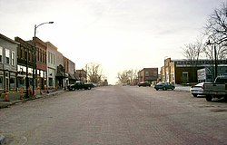
 Downtown Baldwin City (2008) | |
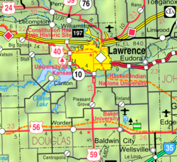
 Location within Douglas County and Kansas | |
 | |
| Coordinates: 38°46′41″N 95°11′17″W / 38.77806°N 95.18806°W[1] | |
| Country | United States |
| State | Kansas |
| County | Douglas |
| Founded | 1850s |
| Incorporated | 1870 |
| Named for | John Baldwin |
| Area | |
| • Total | 2.69 sq mi (6.97 km2) |
| • Land | 2.68 sq mi (6.93 km2) |
| • Water | 0.02 sq mi (0.04 km2) |
| Elevation | 1,066 ft (325 m) |
| Population | |
| • Total | 4,826 |
| • Density | 1,800/sq mi (690/km2) |
| Time zone | UTC-6 (CST) |
| • Summer (DST) | UTC-5 (CDT) |
| ZIP code | 66006 |
| Area code | 785 |
| FIPS code | 20-03900 |
| GNIS ID | 2394055[1] |
| Website | baldwincity.org |
History
changeEarly history
changeBaldwin City started as a trail stop on the Santa Fe Trail. It was called Palmyra. It had a harness shop, blacksmith, hotel, lawyer, drug store, two doctors and a tavern. In 1858, a group of Methodist ministers came together at Kibbee Cabin and created Baker University. Palmyra bought land to the south for the university and the city. The first post office was built in June 1857.[4]
An important person for Baldwin City was John Baldwin. They named the town "Baldwin City" to honor him.[5] Baldwin built a saw mill. It was at present-day Fifth Street and Indiana Street. Baldwin City was incorporated on September 22, 1870.
Baldwin City was affected by the events that led up to the American Civil War. Three miles east of Baldwin was the town of Black Jack. The Battle of Black Jack happened there on June 2, 1856. The night before that battle, John Brown stayed in Prairie City. In 1863, Quantrill's raiders passed within three miles (5 km) of Baldwin after the burning Lawrence.
Geography
changeBaldwin City is at 38°46′39″N 95°11′15″W / 38.77750°N 95.18750°W (38.777597, -95.187418).[6] The United States Census Bureau says that the city has an area of 2.69 square miles (6.97 km2). 2.68 square miles (6.93 km2) of that is land and 0.02 square miles (0.04 km2) is water.[2]
Climate
changeBaldwin City's climate has hot, humid summers and generally mild to cool winters. The Köppen Climate Classification system says that Baldwin City has a humid subtropical climate. It is abbreviated "Cfa" on climate maps.[7]
People
change| Historical population | |||
|---|---|---|---|
| Census | Pop. | %± | |
| 1880 | 325 | — | |
| 1890 | 935 | 187.7% | |
| 1900 | 1,017 | 8.8% | |
| 1910 | 1,386 | 36.3% | |
| 1920 | 1,137 | −18.0% | |
| 1930 | 1,127 | −0.9% | |
| 1940 | 1,096 | −2.8% | |
| 1950 | 1,741 | 58.9% | |
| 1960 | 1,877 | 7.8% | |
| 1970 | 2,520 | 34.3% | |
| 1980 | 2,829 | 12.3% | |
| 1990 | 2,961 | 4.7% | |
| 2000 | 3,400 | 14.8% | |
| 2010 | 4,515 | 32.8% | |
| 2020 | 4,826 | 6.9% | |
| U.S. Decennial Census | |||
Baldwin City is part of the Lawrence Metropolitan Statistical Area.
2020 census
changeIn 2020, there were 4,826 people, 1,651 households, and 1,085 families living in Kansas. Of the households, 65.1% owned their home and 34.9% rented their home. Children under age 18 lived in 34.5% of the households. The median age was 31.5 years. Of the people, 87.7% were White, 2.0% were Black, 1.0% were Native American, 0.7% were Asian, 0.1% were Pacific Islanders, 1.6% were from some other race and 6.9% were two or more races. Hispanic or Latino of any race were 4.3% of the people.[3][8]
2010 census
changeIn 2010, there were 4,515 people, 1,501 households, and 1,011 families living in Lawrence.[9] The people were 93.4% White, 2.1% African American, 0.7% Native American, 0.5% Asian, 0.6% from other races, and 2.7% from two or more races. 3.0% of people were Hispanic or Latino.
There were 1,501 households. 37.5% of them had children under 18 years old; 52.6% of them had married people; 10.2% had only a woman as the main person (with no man); 4.5% had only a man as the main person (with no woman); 32.6% were not families. 26.8% were people living alone, and 12.1% were people over 65 years old living alone. The average number of people living in a household was 2.54. The average number of people in a family was 3.08.
24.3% of the people were under 18 years old; 20.9% of the people were between 18 and 24 years old; 22.9% of the people were between 25 and 44 years old; 20.1% of the people were between 45 and 64 years old; 11.9% were 65 years old or older. 51.5% of the people were women, and 48.5% of the people were men.
2000 census
changeIn 2000, there were 3,400 people, 1,077 households, and 774 families living in Lawrence. The people were 93.62% White, 1.12% African American, 0.74% Native American, 0.62% Asian, 0.06% Pacific Islander, 0.38% from other races, and 3.47% from two or more races. 1.62% of people were Hispanic or Latino.
There were 1,077 households. 39.6% of them had children under 18 years old; 57.8% of them had married people; 10.4% had only a woman as the main person (with no man); 28.1% were not families. 24.8% were people living alone, and 10.0% were people over 65 years old living alone. The average number of people living in a household was 2.59. The average number of people in a family was 3.10.
25.3% of the people were under 18 years old; 21.8% of the people were between 18 and 24 years old; 24.2% of the people were between 25 and 44 years old; 17.4% of the people were between 45 and 64 years old; 11.2% were 65 years old or older. 51.5% of the people were women, and 48.5% of the people were men. The median age was 28 years old. 51.2% of the people were women, and 48.8% of the people were men.
The median income for a household was $43,269. The median income for a family was $51,667. Men had a median income of $37,111. Women had a median income of $25,850. The per capita income was $16,698. About 5.6% of families and 7.6% of all people in Baldwin City lived below the poverty line. This included 11.0% of children under 18 years old and 5.7% of people over 65 years old.
Government
changeThe Baldwin City government has a mayor and five council members. The council meets the first and third Mondays of each month at 7:00pm.[10]
- City Hall, 803 Eighth Street.
Education
changePrimary and secondary education
changeThe USD 348 School District is in Baldwin City. They have most students in southern Douglas County. It has four schools in Baldwin City (Baldwin Elementary, Baldwin Intermediate, Baldwin Junior High, and Baldwin High School). On December 13, 2010, the USD 348 Board of Education voted to close the schools in Vinland and Worden at the end of the 2010-2011 school year.[11]
- Baldwin High School's mascot is the Bulldogs.
College
changeBaldwin City has Baker University. It is a liberal arts university created in 1858 by United Methodist ministers. It is the oldest four-year university in Kansas. It has been coed since it was created.
Media
changeBaldwin City had a newspaper, the Baldwin City Sign. It stopped publishing in 2015. It was moved to the Lawrence Journal-World.[12]
Gallery
change-
To the right of the sign are remnants of wagon ruts left from the Santa Fe Trail in the Ivan Boyd Prairie Preserve near Baldwin City. Also was the site of Black Jack.
-
The Santa Fe Depot for the Midland Railway in west Baldwin City.
-
Aerial View of Baldwin City
Related pages
changeReferences
change- ↑ 1.0 1.1 1.2 U.S. Geological Survey Geographic Names Information System: Baldwin City, Kansas
- ↑ 2.0 2.1 "2020 U.S. Gazetteer Files". United States Census Bureau. Retrieved December 14, 2023.
- ↑ 3.0 3.1 3.2 "DP1: PROFILE OF GENERAL POPULATION AND HOUSING CHARACTERISTICS". United States Census Bureau. Retrieved December 14, 2023.
- ↑ "Kansas Post Offices, 1828-1961 (archived)". Kansas Historical Society. Archived from the original on March 10, 2013. Retrieved 8 June 2014.
- ↑ Kansas State Historical Society (1916). Biennial Report of the Board of Directors of the Kansas State Historical Society. Kansas State Printing Plant. p. 181.
- ↑ "US Gazetteer files: 2010, 2000, and 1990". United States Census Bureau. 2011-02-12. Retrieved 2011-04-23.
- ↑ "Baldwin City, Kansas Köppen Climate Classification (Weatherbase)". Weatherbase. Retrieved 22 April 2018.
- ↑ "P16: HOUSEHOLD TYPE". United States Census Bureau. Retrieved December 30, 2023.
- ↑ "American FactFinder". United States Census Bureau. Retrieved 2012-07-06.
- ↑ Baldwin City - Directory of Public Officials Archived 2011-05-05 at the Wayback Machine
- ↑ "Archived copy". Archived from the original on 2012-05-14. Retrieved 2019-07-08.
{{cite web}}: CS1 maint: archived copy as title (link) - ↑ "Bladwin City Signal ending publication with current edition". Baldwin City Signal. Baldwin City, KS. December 30, 2015. Archived from the original on July 10, 2019. Retrieved July 8, 2019.
Other websites
change- City
- Schools
- USD 348, local school district
- Historical
- Maps
- Baldwin City Map, KDOT

