Mosken
Jump to navigation
Jump to search
 | |
 | |
| Geography | |
|---|---|
| Location | Nordland, Norway |
| Coordinates | 67°44′45″N 12°45′19″E / 67.7458°N 12.7554°E |
| Archipelago | Lofoten |
| Area | 1.5 km2 (0.58 sq mi) |
| Length | 2.2 km (1.37 mi) |
| Width | 1.2 km (0.75 mi) |
| Highest elevation | 385 m (1263 ft) |
| Highest point | Wilhelmstind |
| Administration | |
Norway | |
| County | Nordland |
| Municipality | Værøy Municipality |
| Demographics | |
| Population | 0 (2018) |
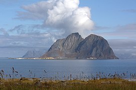
Mosken is a small uninhabited rocky island in Værøy Municipality in Nordland county, Norway. The 1.5-square-kilometre (0.58 sq mi) island is located in the Lofoten archipelago about halfway between the islands of Værøya to the south and Moskenesøya to the north. The Moskenstraumen maelstrom—one of the most powerful in the world—is located on the north side of the island of Mosken.[1][2] Historically, the island was used for grazing sheep in both the summer and the winter.[3]
Media gallery
-
Mosken with Moskenesøya in the background
-
Moskenstraumen with Mosken and Værøy in the background and Moskenesøy to the right
-
View of Mosken, seen from the sea
-
View of Mosken from Værøy, looking north
See also
References
- ^ "Maelstrom". Encyclopædia Britannica.
- ^ Store norske leksikon. "Moskenesstraumen" (in Norwegian). Retrieved 2012-03-05.
- ^ "Værøy". GoNorway.no. Retrieved 2012-03-05.
Categories:
- Pages using gadget WikiMiniAtlas
- CS1 Norwegian-language sources (no)
- Articles with short description
- Short description is different from Wikidata
- Infobox mapframe without OSM relation ID on Wikidata
- Coordinates on Wikidata
- Lofoten
- Værøy
- Islands of Nordland
- Uninhabited islands of Norway
- All stub articles
- Nordland island stubs
- Pages using the Kartographer extension


