Sea of Marmara
| Sea of Marmara | |
|---|---|
| Marmara Denizi (Turkish) | |
 | |
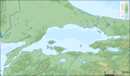
 Bathymetry and surrounding relief | |
| Location | Southern Europe and West Asia |
| Coordinates | 40°40′N 28°00′E / 40.667°N 28.000°E |
| Type | Inland sea |
| Primary inflows | Simav River, Biga Çayı, Nilüfer River |
| Primary outflows | Turkish Straits |
| Catchment area | 11,500 km2 (4,400 sq mi) |
| Basin countries | Turkey |
| Surface area | 11,350 km2 (4,380 sq mi) |
| Average depth | 494 m (1,621 ft) |
| Max. depth | 1,370 m (4,490 ft) |
| Water volume | 3,378 km3 (810 cu mi) |
| Islands | Marmara Island, Avşa, İmralı, Prince Islands, Paşalimanı and Ekinlik Island |
| Settlements | Istanbul, Bursa, İzmit, Tekirdağ, Balıkesir, Çanakkale, and Yalova |


The Sea of Marmara,[a] also known as the Sea of Marmora or the Marmara Sea, is a small inland sea located entirely within the borders of Turkey. It connects the Black Sea to the Aegean Sea via the Bosporus and Dardanelles straits, separating Turkey’s European and Asian sides. It has an area of 11,350 km2 (4,380 sq mi), and its dimensions are 280 km × 80 km (174 mi × 50 mi).[1] Its greatest depth is 1,370 m (4,490 ft).
Name
The Sea of Marmara is named after the largest island on its south side, called Marmara Island because it is rich in marble (Greek μάρμᾰρον, mármaron 'marble').[2]
In classical antiquity, it was known as the Propontis, from the Greek words pro 'before' and pontos 'sea', reflecting the fact that the Ancient Greeks used to sail through it to reach the Black Sea, which they called Pontos.
Mythology
In Greek mythology, a storm on the Propontis brought the Argonauts back to an island they had left, precipitating a battle in which either Jason or Heracles killed King Cyzicus, who had mistaken them for his Pelasgian enemies.[3]
Geography and hydrology
The International Hydrographic Organization defines the limits of the Sea of Marmara as follows:[4]
On the West. The Dardanelles limit of the Aegean Sea [A line joining Kum Kale (26°11'E) and Cape Helles].
On the Northeast. A line joining Cape Rumili with Cape Anatoli (41°13′N). The sea's south coast is heavily indented and includes the Gulf of İzmit (Turkish: İzmit Körfezi), the Gulf of Gemlik (Turkish: Gemlik Körfezi), the Gulf of Bandırma (Turkish: Bandırma Körfezi), and the Gulf of Erdek (Turkish: Erdek Körfezi).
The surface salinity of the Marmara averages about 22 parts per thousand, which is slightly more than that of the Black Sea, but only about two-thirds that of most oceans. The water is much more saline at the bottom of the sea, averaging a salinity of around 38 parts per thousand, similar to that of the Mediterranean Sea. This high-density saline water does not migrate to the surface as is also the case with the Black Sea. Water from the Susurluk, Biga (Granicus), and Gönen Rivers also reduces the salinity of the sea, though with less effect than on the Black Sea. With little land in Thrace draining southward, almost all of these rivers flow from Anatolia.
Islands
There are two main groups of islands in the Sea of Marmara. To the north lie the Princes' Islands, an archipelago made up of the inhabited islands of Kınaliada, Burgazada, Heybeliada, Büyükada and Sedef Adası and several uninhabited islands including Sivriada, Yassıada, Kaşıkadası and Tavşanadası. The inhabited islands are readily accessible by ferry from both the European and Asian shores of İstanbul and the entire archipelago forms part of the conurbation.
To the south lie the Marmara Islands, an archipelago made up of the eponymous Marmara Island and three other inhabited islands – Avşa, Paşalimanı and Ekinlik – as well as of seventeen largely uninhabited islands including the prison island of Imralı whose most famous prisoner, since 1999, has been the PKK leader Abdullah Öcalan. These islands lie within Balıkesir province and are most readily accessible from Tekirdağ in Thrace or Erdek on the southern shore of the Sea of Marmara. In high summer additional ferries travel to Avşa and Marmara Islands from the centre of İstanbul to facilitate a growing tourist trade.
There are also a few individual islands elsewhere in the Sea of Marmara, such as Koç Adası, off Tuzla, which is privately owned by the Koç family of industrialists.
Problems facing the Sea of Marmara
The North Anatolian Fault runs under the sea and has triggered several major earthquakes, such as those in Izmit and Düzce in August and November 1999 respectively. The August 1999 earthquake is commonly referred to as the Marmara Earthquake since its epicentre lay under the Sea and most of the places worst affected by the quake and ensuing tsunami lay along its shores.[5]
During a storm on 29 December 1999, the Russian oil tanker Volgoneft broke in two in the Sea of Marmara, spilling more than 1,500 tonnes of oil into the water.[6]
In 2021 the shores of the Sea of Marmara were disfigured by marine mucilage - nicknamed 'sea snot' - caused, at least in part, by the dumping of untreated waste into the water.[7]
Towns and cities
Towns and cities on the coast of the Sea of Marmara include:
| Istanbul Province | Balıkesir Province | Kocaeli Province
|
Yalova Province |
Gallery
-
The Bosporus with Istanbul in the background
-
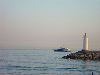
View of Marmara Sea from Istanbul
-
Sea of Marmara approaching Yassıada
See also
- 1509 Constantinople earthquake
- 1766 Istanbul earthquake
- 1999 İzmit earthquake
- Black Sea deluge hypothesis
- Kanal İstanbul
- Montreux Convention Regarding the Regime of the Straits
- Turkish Straits
Notes
- ^ /ˈmɑːrmərə/; Turkish: Marmara Denizi; Ancient Greek: Προποντίς, Προποντίδα, romanized: Propontís, Propontída
References
- ^ "Marmara, Sea of - Dictionary definition of Marmara, Sea of - Encyclopedia.com: FREE online dictionary". www.encyclopedia.com. Retrieved 3 January 2018.
- ^ Liddell, Henry George; Scott, Robert. "A Greek-English Lexicon". Henry Stuart Jones and Roderick McKenzie. Perseus. Retrieved 12 January 2009.
- ^ Parada, Carlos. "Greek Mythology Link". Archived from the original on 13 February 2002. Retrieved 30 April 2001.
- ^ "Limits of Oceans and Seas" (PDF) (3rd ed.). International Hydrographic Organization. 1953. Retrieved 28 December 2020.
- ^ "Marmara earthquake: 20 years on | IFRC". www.ifrc.org. Retrieved 1 August 2022.
- ^ Otay, Emre N; Yenigün, Orhan (January 2001). "The Volgoneft-248 Oil Spill in the Marmara Sea". ResearchGate. Archived from the original on 25 October 2022. Retrieved 16 June 2023.
- ^ "Impact of mucilage in Marmara Sea to be less harsh: Expert - Türkiye News". Hürriyet Daily News. Retrieved 1 August 2022.
External links
- "Sea of Marmara" at the Encyclopædia Britannica
- "Sea of Marmara: Where Ancient Myth and Modern Science Mix" at SCIENCE FOCUS – SeaWiFS
- Pages using gadget WikiMiniAtlas
- Articles containing Turkish-language text
- Articles containing Ancient Greek (to 1453)-language text
- Use dmy dates from June 2023
- Articles with short description
- Short description is different from Wikidata
- Coordinates on Wikidata
- Articles using infobox body of water without alt
- Articles using infobox body of water without pushpin map alt
- Articles using infobox body of water without alt bathymetry
- Commons category link from Wikidata
- Sea of Marmara
- Ancient Greek geography
- Seas of the Mediterranean Sea
- Seas of Turkey
- Marmara Region
- Geography of Europe
- Geography of West Asia
- Landforms of Istanbul Province
- Landforms of Balıkesir Province
- Landforms of Bursa Province
- Landforms of Çanakkale Province
- Landforms of Kocaeli Province
- Landforms of Tekirdağ Province
- Landforms of Yalova Province
- European seas


