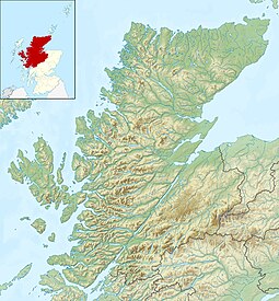
Longay
Jump to navigation
Jump to search
| Scottish Gaelic name | Longaigh |
|---|---|
| Old Norse name | Long-øy |
| Meaning of name | longship island |
| Location | |
| OS grid reference | NG658310 |
| Coordinates | 57°19′N 5°53′W / 57.31°N 5.89°W |
| Physical geography | |
| Island group | Skye |
| Area | 50 ha (3⁄16 sq mi) |
| Area rank | 199= [1] |
| Highest elevation | 67 m (220 ft) |
| Administration | |
| Council area | Highland |
| Country | Scotland |
| Sovereign state | United Kingdom |
| Demographics | |
| Population | 0 |
| References | [2][3][4] |

Longay (Scottish Gaelic: Longaigh) is a small uninhabited Scottish island in the Inner Sound just off the coast of the Isle of Skye, north of Pabay and east of Scalpay.[5][6]
In 1971, the Caledonian MacBrayne mailboat Loch Seaforth ran aground on the island, sustaining only minimal damage.[7]
References
Wikimedia Commons has media related to Longay.
- ^ Area and population ranks: there are c. 300 islands over 20 ha in extent and 93 permanently inhabited islands were listed in the 2011 census.
- ^ 2001 UK Census per List of islands of Scotland
- ^ Haswell-Smith, Hamish (2004). The Scottish Islands. Edinburgh: Canongate. ISBN 978-1-84195-454-7.
- ^ Ordnance Survey
- ^ "Overview of Longay". Gazetteer for Scotland. Retrieved 4 October 2008.
- ^ "History of Longay". Gazetteer for Scotland. Retrieved 4 October 2008.
- ^ "Loch Seaforth - History". Ships of Calmac. Archived from the original on 14 June 2011. Retrieved 4 October 2008.
57°18′36″N 5°53′23″W / 57.31000°N 5.88972°W
Categories:
- Pages using gadget WikiMiniAtlas
- Use dmy dates from April 2022
- Articles containing Scottish Gaelic-language text
- Articles containing Old Norse-language text
- Articles with OS grid coordinates
- Commons category link is on Wikidata
- Coordinates on Wikidata
- Uninhabited islands of Highland (council area)
- All stub articles
- Highland geography stubs


