Convergent plate boundaries are locations where lithospheric plates are moving towards one another. The plate collisions that occur in these areas can produce earthquakes, volcanic activity, and crustal deformation.
Convergent Plate Boundary - Oceanic and Continental Plates |
 |
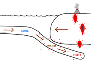
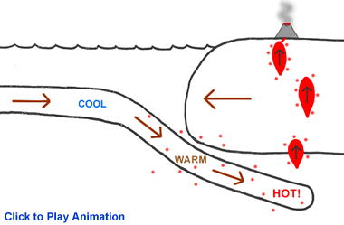
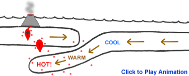
When continental and oceanic plates collide, the thinner and more dense oceanic plate is overridden by the thicker and less dense continental plate. The oceanic plate is forced down into the mantle in a process known as "subduction." As the oceanic plate descends, it is forced into higher temperature environments. At a depth of about 100 miles (160 km), materials in the subducting plate begin to approach their melting temperatures and a process of partial melting begins.
This partial melting produces magma chambers above the subducting oceanic plate. These magma chambers are less dense than the surrounding mantle materials and are buoyant. The buoyant magma chambers begin a slow ascent through the overlying materials, melting and fracturing their way upwards. The size and depth of these magma chambers can be determined by mapping the earthquake activity around them. If a magma chamber rises to the surface without solidifying, the magma will break through in the form of a volcanic eruption.
The Washington-Oregon coastline of the United States is an example of this type of convergent plate boundary. Here the Juan de Fuca oceanic plate is subducting beneath the westward-moving North American continental plate. The Cascade Mountain Range is a line of volcanoes above the melting oceanic plate. The Andes Mountain Range of western South America is another example of a convergent boundary between an oceanic and continental plate. Here the Nazca Plate is subducting beneath the South American plate.
Visit the Interactive Plate Boundary Map to explore satellite images of convergent boundaries between oceanic and continental plates. Two locations are marked to show this type of plate boundary - the Cascade volcanoes along the Washington-Oregon coast of North America and the Andes mountain range on the western margin of South America.
Effects of a convergent boundary between an oceanic and continental plate include: a zone of earthquake activity that is shallow along the continent margin but deepens beneath the continent; sometimes an ocean trench immediately off shore of the continent; a line of volcanic eruptions a few hundred miles inland from the shoreline; destruction of oceanic lithosphere.
Convergent Plate Boundary - Oceanic |
 |
When a convergent boundary occurs between two oceanic plates, one of those plates will subduct beneath the other. Normally the older plate will subduct because of its higher density. The subducting plate is heated as it is forced deeper into the mantle, and at a depth of about 100 miles (150 km) the plate begins to melt. Magma chambers are produced as a result of this melting, and the magma is lower in density than the surrounding rock material. It begins ascending by melting and fracturing its way through the overlying rock material. Magma chambers that reach the surface break through to form a volcanic eruption cone. In the early stages of this type of boundary, the cones will be deep beneath the ocean surface but later grow to be higher than sea level. This produces an island chain. With continued development the islands grow larger, merge, and an elongate landmass is created.
Japan, the Aleutian Islands, and the Eastern Caribbean islands of Martinique, St. Lucia, and St. Vincent and the Grenadines are examples of islands formed through this type of plate boundary. Visit the Interactive Plate Boundary Map to explore satellite images of these three areas.
Effects that are found at this type of plate boundary include: a zone of progressively deeper earthquakes; an oceanic trench; a chain of volcanic islands; the destruction of oceanic lithosphere.
Convergent Plate Boundary - Continental |
 |
This is a difficult boundary to draw. First it is complex and second, it is poorly understood when compared to the other types of plate boundaries. In this type of convergent boundary, a powerful collision occurs. The two thick continental plates collide, and both of them have a density that is much lower than the mantle, which prevents subduction (there may be a small amount of subduction, or the heavier lithosphere below the continental crust might break free from the crust and subduct).
Fragments of crust or continent margin sediments might be caught in the collision zone between the continents, forming a highly deformed melange of rock. The intense compression can also cause extensive folding and faulting of rocks within the two colliding plates. This deformation can extend hundreds of miles into the plate interior.
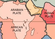
The Himalaya Mountain Range is the best active example of this type of plate boundary. Visit the Interactive Plate Boundary Map to explore satellite images of the Himalaya Range where the Indian and Eurasian plates are currently in collision. The Appalachian Mountain Range is an ancient example of this collision type and is also marked on the map.
Effects found at a convergent boundary between continental plates include: intense folding and faulting; a broad folded mountain range; shallow earthquake activity; shortening and thickening of the plates within the collision zone.
Contributor: Hobart King
Publisher, Geology.com
Find Other Topics on Geology.com:
 | Rocks: Galleries of igneous, sedimentary and metamorphic rock photos with descriptions. |
|
 | Minerals: Information about ore minerals, gem materials and rock-forming minerals. |
|
 | Volcanoes: Articles about volcanoes, volcanic hazards and eruptions past and present. |
|
 | Gemstones: Colorful images and articles about diamonds and colored stones. |
|
 | General Geology: Articles about geysers, maars, deltas, rifts, salt domes, water, and much more! |
|
 | Geology Store: Hammers, field bags, hand lenses, maps, books, hardness picks, gold pans. |
|

|
 | Diamonds: Learn about the properties of diamond, its many uses, and diamond discoveries.
|
|
