Vajnory
Vajnory | |
|---|---|
Borough | |
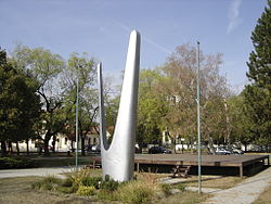
 Monument to the Red Army in Vajnory | |
 Area of Vajnory in Bratislava | |
| Coordinates: 48°08′00″N 17°07′00″E / 48.13333°N 17.11667°E | |
| Country | |
| Region | |
| District | Bratislava III |
| First mentioned | 1237 |
| Government | |
| • Mayor | Michal Vlček |
| Area | |
• Total | 13.53 km2 (5.22 sq mi) |
| Elevation | 130 m (430 ft) |
| Population (1 January 2021) | |
• Total | 6,079 |
| • Density | 450/km2 (1,200/sq mi) |
| Time zone | UTC+1 (CET) |
| • Summer (DST) | UTC+2 (CEST) |
| Postal code | 831 07 |
| Area code | +421-2 |
| Car plate | BA, BL, BT |
| Website | www |
Vajnory is a small borough in the northeast of Bratislava, Slovakia.
Milan Rastislav Štefánik international airport is located near Vajnory. Another airport - Vajnory Airport, which was the first airport in Slovakia - closed in 2006.
History
[edit]The first written mention of Vajnory dates to 1237, when it was a village with the original Slovak Slovak name Prača / Pračany. In 1307, Heiligenkreuz Abbey in Austria purchased it and renamed it Weinern, referring to the main occupation of the villagers, working on vineyards and making wine. A relic of this name remains today in the Slovak variant, Vajnory. It was purchased again by Bratislava in the 16th century. It was a borough only until 1851, when, shortly after the abolition of serfdom, Vajnory became an independent village again. It was made an official borough of Bratislava in 1946.
Photogallery
[edit]-
Municipality of Vajnory
-
The map of Vajnory
-
The church tower
-
Statue of St. Florián
-
Elementary school of Katarína Brúderová
-
Elementary school of John Paul II
-
Nature reserve Šúr close to Vajnory
-
Main street in Vajnory


