Rue Royale, Brussels
 | |
| Location | Brussels-Capital Region, Belgium |
|---|---|
| Coordinates | 50°51′01″N 04°21′51″E / 50.85028°N 4.36417°E |
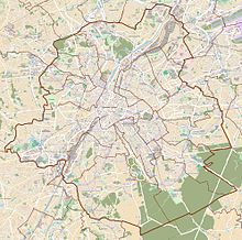
The Rue Royale (French: [ʁy ʁwa.jal], "Royal Street") or Koningsstraat (Dutch, "King's Street") is a street in Brussels, Belgium, running through the municipalities of Schaerbeek, Saint-Josse-ten-Noode and the City of Brussels. It is limited to the south by the Place Royale/Koningsplein in the city centre and to the north by the Place de la Reine/Koninginplein in Schaerbeek.[1][2][3]
Several places of interest lie along the Rue Royale, for instance the BELvue Museum, Brussels Park, the Congress Column, the Hotel Astoria, the Botanical Garden of Brussels, Le Botanique concert hall and Saint Mary's Royal Church. In addition, many companies have offices on the street, for instance Accenture and BNP Paribas Fortis, as well as the French-speaking Community of Belgium.
Two metro stations can be accessed from the Rue Royale: Parc/Park metro station and Botanique/Kruidtuin metro station. The street is continued to the north by the Rue Royale Sainte-Marie/Koninklijke Sinte-Mariastraat and to the south by the Rue de la Régence/Regentschapsstraat. It also crosses the Small Ring (Brussels' inner ring road) at the Boulevard du Jardin botanique/Kruidtuinlaan crossroad.
History
[edit]The Rue Royale was laid out in 1777 between the Place Royale/Koningsplein and the Place de Louvain/Leuvenseplein, which required enormous levelling works. From 1822, the street was extended to the Schaerbeek Gate on the current Small Ring by the engineer Jean-Alexandre Werry and the architect Hendrik Partoes. Shortly afterwards, it was extended even further on the territory of Saint-Josse-ten-Noode to the newly constructed Place de la Reine/Koninginplein in Schaerbeek, where Saint Mary's Royal Church closes the kilometre-long perspective.
In November 1902, King Leopold II was attacked by the Italian anarchist Gennaro Rubino on the Rue Royale and escaped death. However, his Grand Marshall, Count Charles d'Oultremont, was almost killed.[4][5]
Gallery
[edit]-
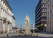
Statue of Augustin Daniel Belliard (Geefs, 1836) on the Rue Royale
-
The Congress Column and the Finance Tower seen from the Rue Royale
-
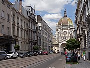
Saint Mary's Royal Church from the Rue Royale
See also
[edit]- List of streets in Brussels
- Neoclassical architecture in Belgium
- History of Brussels
- Belgium in the long nineteenth century
References
[edit]Citations
[edit]- ^ "Rue Royale – Inventaire du patrimoine architectural". monument.heritage.brussels (in French). Retrieved 4 November 2023.
- ^ "Rue Royale – Inventaire du patrimoine architectural". monument.heritage.brussels (in French). Retrieved 4 November 2023.
- ^ "Rue Royale – Inventaire du patrimoine architectural". monument.heritage.brussels (in French). Retrieved 4 November 2023.
- ^ "Attentat contre le roi des Belges". La Meuse (in French). 17 November 1902. pp. 1–2.
- ^ Journal De Charleroi, 16 November 1902
Bibliography
[edit]- Francis, Jean (1975). La Chanson des rues de Schaerbeek (in French). Brussels: Louis Musin Éditeur. p. 136.
- Le Patrimoine monumental de la Belgique: Bruxelles (PDF) (in French). Vol. 1C: Pentagone N-Z. Liège: Pierre Mardaga. 1994. p. 240–262.
External links
[edit] Media related to Rue Royale/Koningsstraat, Brussels at Wikimedia Commons


