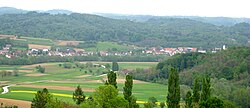
Rogašovci
Appearance
Rogašovci
Rogačovci | |
|---|---|
 | |
| Coordinates: 46°48′19.13″N 16°2′3.98″E / 46.8053139°N 16.0344389°E | |
| Country | |
| Traditional region | Prekmurje |
| Statistical region | Mura |
| Municipality | Rogašovci |
| Area | |
| • Total | 2.95 km2 (1.14 sq mi) |
| Elevation | 237.9 m (780.5 ft) |
| Population (2019)[1] | |
| • Total | 2,946 |
Rogašovci (pronounced [ɾɔˈɡaːʃɔu̯tsi]; Prekmurje Slovene and in older sources: Rogačovci,[2][3] Hungarian: Szarvaslak[3]) is a settlement in Slovenia.[4] It is the seat of the Municipality of Rogašovci. It is part of the Prekmurje region.
References
[edit]- ^ a b "Naselje Rogašovci". Statistični urad Republike Slovenije. Retrieved February 10, 2020.
- ^ Jakopin 1985, p. 239.
- ^ a b Vengušt, Jernej. 1919. Seznamek prekmurskih občin (krajev) z označbo pošte in zemljevidom. Radgona, p. 13.
- ^ Rogašovci municipal site
External links
[edit] Media related to Rogašovci at Wikimedia Commons
- Rogašovci on Geopedia
Bibliography
[edit]- Jakopin, Franc (1985). Sluga, Meta (ed.). Slovenska krajevna imena. Ljubljana: Cankarjeva založba.


