Prallsville, New Jersey
Prallsville, New Jersey | |
|---|---|
 Mill in Prallsville | |
| Coordinates: 40°24′42″N 74°59′12″W / 40.41167°N 74.98667°W | |
| Country | |
| State | |
| County | Hunterdon |
| Borough and Township | Stockton and Delaware |
| Elevation | 85 ft (26 m) |
| GNIS feature ID | 879475[1] |
Prallsville is an unincorporated community located along New Jersey Route 29 by the border of Stockton and Delaware Township in Hunterdon County, New Jersey.[2] The Delaware River and Wickecheoke Creek border the community.[3] The Prallsville District was listed on the National Register of Historic Places in 1979.
History
[edit]The feeder canal for the Delaware and Raritan Canal, which runs along the Delaware River, was built through the community in the 1830s. Later, in the 1850s, the Belvidere-Delaware Railroad was built along the canal and a station built here.[4]
Historic district
[edit]Prallsville District | |
 Mill along the Feeder Canal of the Delaware and Raritan Canal | |
| Location | NJ Route 29, Delaware River and Wickecheoke Creek |
|---|---|
| Area | 17 acres (6.9 ha) |
| Built | 1790 |
| Architectural style | Greek Revival |
| NRHP reference No. | 79001498[5] |
| NJRHP No. | 1629[6] |
| Significant dates | |
| Added to NRHP | June 27, 1979 |
| Designated NJRHP | August 16, 1976 |
The Prallsville District is a 17-acre (6.9 ha) historic district encompassing the village. It was added to the National Register of Historic Places on June 27, 1979 for its significance in industry. It includes 15 contributing buildings and 2 contributing structures.[3] The district is also known as Prallsville Mills after John Prall Jr. who bought them in 1794.[7]
The area is part of the Delaware and Raritan Canal State Park and serves as open-air museum.[4][8]
Gallery
[edit]-
Grist Mill and Grain Silo
-
Lock on the Feeder Canal of the Delaware and Raritan Canal
-
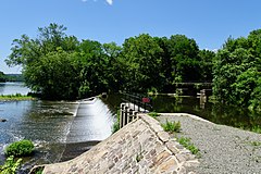
Feeder Canal overflow spillway for the Wickecheoke Creek
References
[edit]- ^ a b "Prallsville". Geographic Names Information System. United States Geological Survey, United States Department of the Interior.
- ^ Locality Search, State of New Jersey. Accessed January 31, 2015.
- ^ a b Karschner, Terry (June 1979). "National Register of Historic Places Inventory/Nomination: Prallsville District". National Park Service. With accompanying 31 photos
- ^ a b "Points of Interest: Prallsville Mill". D & R Canal State Park.
- ^ "National Register Information System – (#79001498)". National Register of Historic Places. National Park Service. November 2, 2013.
- ^ "New Jersey and National Registers of Historic Places – Hunterdon County" (PDF). New Jersey Department of Environmental Protection – Historic Preservation Office. September 30, 2020. p. 15.
- ^ "History of the Prallsville Mills". Delaware River Mill Society.
- ^ "Prallsville Mills". Delaware River Mill Society.
External links
[edit] Media related to Prallsville Mills at Wikimedia Commons
- "Prallsville Grist Mill". The Historical Marker Database.
- Stockton, New Jersey
- Delaware Township, Hunterdon County, New Jersey
- Unincorporated communities in Hunterdon County, New Jersey
- Unincorporated communities in New Jersey
- National Register of Historic Places in Hunterdon County, New Jersey
- Historic districts on the National Register of Historic Places in New Jersey
- New Jersey Register of Historic Places
- Museums in Hunterdon County, New Jersey
- Open-air museums in New Jersey


