Pomerape
| Pomerape | |
|---|---|
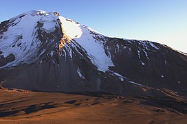
 Pomerape and the saddle below, as seen from south (Parinacota slopes) | |
| Highest point | |
| Elevation | 6,282 m (20,610 ft)[1] |
| Coordinates | 18°07′33″S 69°07′39″W / 18.12583°S 69.12750°W |
| Geography | |
| Parent range | Andes |
| Geology | |
| Rock age | Pleistocene |
| Mountain type | Stratovolcano |
| Climbing | |
| Easiest route | snow/ice climb |
Pomerape is a stratovolcano lying on the border of northern Chile and Bolivia (Oruro Department, Sajama Province, Curahuara de Carangas Municipality).[2] It is part of the Payachata complex of volcanoes, together with Parinacota Volcano to the south. The name "Payachata" means "twins" and refers to their appearance.[3] It hosts glaciers down to elevations of 5,300–5,800 metres (17,400–19,000 ft), lower on the northern slope.[4]
Pomerape is a complex of lava domes, accompanied by lava flows which were emplaced atop of the domes.[5] It was active about 200,000 years ago.[6] The lava domes formed first and were later buried by the actual volcanic cone, which unlike the rhyolitic-dacitic domes is formed by hornblende andesite.[7] The "Chungará Andesites" and lava dome complex of Parinacota were laid down at this time.[8] Pomerape is associated with an adventive vent that has erupted mafic magmas. The main cone was last active 106,000 +- 7,000 years ago,[9] the adventive vent is dated to 205,000 ± 24,000 years ago.[10]
Climbing the volcano is alpine grade PD by the east ridge.[11] Harder routes exist on the south face, sometimes on 50+ degree snow/rubble slope. For these routes a camp can be established at 5,300 metres (17,390 ft) at the saddle between Parinacota and Pomerape. Depending on the season, the main difficulty can be penitentes (tall ice-blade needles), which make the ascent physically difficult or impossible.
See also
[edit]References
[edit]- ^ Chilean IGM elevation Archived 2007-09-27 at the Wayback Machine
- ^ Map of Curahuara de Carangas Municipality and population data. Archived 2014-11-11 at the Wayback Machine
- ^ Schull, William J. (1990). "Introduction: The Place and the Study". In Schull, William J.; Rothhammer, Francisco (eds.). The Aymara. Studies in Human Biology. Vol. 2. Springer Netherlands. pp. 1–18. doi:10.1007/978-94-009-2141-2_1. ISBN 9789401074636.
- ^ Carrasco, Jorge F.; Osorio, Roberto; Casassa, Gino (2008-07-01). "Secular trend of the equilibrium-line altitude on the western side of the southern Andes, derived from radiosonde and surface observations". Journal of Glaciology. 54 (186): 545. Bibcode:2008JGlac..54..538C. doi:10.3189/002214308785837002.
- ^ Gonzalez-Ferran, Oscar (1994). Volcanes de Chile (in Spanish) (1st ed.). Santiago, Chile: Instituto geografico militar. p. 113. ISBN 9789562020541.
- ^ Wörner, Gerhard; Moorbath, Stephen; Horn, Susanne; Entenmann, Jürgen; Harmon, Russel S.; Davidson, Jon P.; Lopez-Escobar, Leopoldo (1994). Reutter, Professor Dr Klaus-Joachim; Scheuber, Dr Ekkehard; Wigger, Dr Peter J. (eds.). Tectonics of the Southern Central Andes. Springer Berlin Heidelberg. p. 81. doi:10.1007/978-3-642-77353-2_5. ISBN 9783642773556.
- ^ Wörner, G.; Harmon, R. S.; Davidson, J.; Moorbath, S.; Turner, D. L.; McMillan, N.; Nyes, C.; Lopez-Escobar, L.; Moreno, H. (1988-09-01). "The Nevados de Payachata volcanic region (18°S/69°W, N. Chile)" (PDF). Bulletin of Volcanology. 50 (5): 287–303. Bibcode:1988BVol...50..287W. doi:10.1007/BF01073587. hdl:2027.42/47805. ISSN 0258-8900. S2CID 129099050.
- ^ Hora, J. M.; Singer, B. S.; Worner, G. (2007). "Volcano evolution and eruptive flux on the thick crust of the Andean Central Volcanic Zone: 40Ar/39Ar constraints from Volcan Parinacota, Chile". Geological Society of America Bulletin. 119 (3–4): 343–362. Bibcode:2007GSAB..119..343H. doi:10.1130/b25954.1.
- ^ Wörner, Gerhard; Hammerschmidt, Konrad; Henjes-Kunst, Friedhelm; Lezaun, Judith; Wilke, Hans (2000-12-01). "Geochronology (40Ar/39Ar, K-Ar and He-exposure ages) of Cenozoic magmatic rocks from Northern Chile (18-22°S): implications for magmatism and tectonic evolution of the central Andes". Revista Geológica de Chile. 27 (2): 205–240. ISSN 0716-0208.
- ^ Gonzalez-Ferran, Oscar (1994). Volcanes de Chile (1st ed.). Santiago, Chile: Instituto geografico militar. p. 113. ISBN 9789562020541.
- ^ Biggar, John (2020). The Andes - A Guide for Climbers and Skiers (5th ed.). Scotland: Andes. p. 192. ISBN 978-0-9536087-6-8.
- "Parinacota". Global Volcanism Program. Smithsonian Institution. (includes Pomerape)
- Volcanoes of Arica y Parinacota Region
- Stratovolcanoes of Chile
- Subduction volcanoes
- Volcanoes of Oruro Department
- Mountains of Arica y Parinacota Region
- Pleistocene stratovolcanoes
- Polygenetic volcanoes
- Dormant volcanoes
- Bolivia–Chile border
- International mountains of South America
- Six-thousanders of the Andes
- Oruro Department geography stubs
- Chile geography stubs
- South America mountain stubs


