Nubra River
| Nubra River Yarma Tsangpo | |
|---|---|
 Nubra River | |
 Nubra/ Shyok watershed | |
| Location | |
| Country | India |
| Union Territory | Ladakh |
| Region | Ladakh |
| District | Leh |
| Physical characteristics | |
| Source | 35°12′38″N 77°11′46″E / 35.21056°N 77.19611°E |
| • location | Siachen Glacier |
| • elevation | 3,720 m (12,200 ft) |
| Mouth | |
• location | Shyok river at Khalsar |
• coordinates | 34°35′33″N 77°34′50″E / 34.59250°N 77.58056°E |
• elevation | 3,126 m (10,256 ft) |
| Length | 80 km (50 mi) |
| Basin size | 4,378 km2 (1,690 sq mi)[1] |
| Basin features | |
| River system | Indus River |
The Nubra River is a river in the Nubra Valley of Ladakh in India. It is a tributary of the Shyok River (a part of the Indus River system) and originates from the Siachen Glacier,[2] the second-longest non-polar glacier in the world.[3][4] In earlier Tibetan maps, it was referred to as Yarma Tsangpo.[5]
Geography
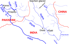
[edit]The Siachen Glacier terminates in a snout located at around 3,570 m (11,700 ft) and two pro-glacial melt-water streams originate out of two ice caves in the region.[6] They merge about one kilometer downstream and becomes the Nubra river.[6][7] Numerous other glaciers of the Karakoram descend into the Nubra.[8] It then flows between the Karakoram range and the Saltoro Mountains in a general southeasterly direction for about 90 kilometres (56 mi) before its confluence with the Shyok River near Diskit, forming the Nubra Valley.[8][6][9]
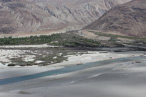
The side valleys of the Nubra Valley contain some 33 glaciers of varying proportions, and the heavy sediment load carried by the river from the melt-water is responsible for many glacio-fluvial deposits including braided channels, outwash plains and alluvial fans.[10] The valley has been formed by ancient glaciers, now long receded, and has an average elevation of 4,000 m (13,000 ft) above sea level. The area has a very arid climate, and the lack of precipitation and the high elevation means that the upper reaches of the valley are nearly devoid of vegetation.[11] At its junction with the Shyok, the sandy flats support patches of Tamarix and Myricaria. There are small villages at the foot of ravines, where poplars and willow trees grow. Small pasture fields have been enclosed on the un-denuded fans and fruit trees are grown.[12]
Siachen Conflict
[edit]The river was rafted by an Indo-German team in 1978[13] under the leadership of Narendra Kumar.[14] Certain features in the maps used by the Germans led to India's understanding of cartographic aggression by Pakistan and a subsequent mountaineering reconnaissance expedition of the region was planned; which in turn led to Operation Meghdoot.[14][15]
Ecological crisis
[edit]The Siachen Glacier, the source of the Nubra River, has for some time[nb 1] been the scene of conflict between India and Pakistan, and has been called the world's highest battleground.[17] The 20,000 troops stationed on the glacier produce a lot of waste,[nb 2] 40% of which is plastic and metal. This debris, including irreparable vehicles, war debris, parachute material, canisters, clothing, and human waste, is simply tipped into crevasses in the glacier. With no natural biodegradation taking place, the ice is being permanently contaminated by toxins such as cobalt, cadmium, and chromium. The washing of warfare clothes at hot sulfur springs near the Indian base camp also contaminates the river. The toxins will eventually reach the Indus River, with millions of downstream users potentially being impacted.[18][19][20]
Tourism
[edit]There are many monasteries (gompa) including Samstanling Monastery the main monastery in the valley and Diskit Monastery for viewing tall statue of Maitreya Buddha and Ensa Monastery. Visit Panamik village for mountain views, Yarab Tso lake, Hunder Sand Dunes for Bactrian camel safari, Turtuk the border village for landscape & local unique culture.[21]
See also
[edit]Notes
[edit]- ^ The conflict began in 1984 with India's successful Operation Meghdoot during which it gained control over all of the Siachen Glacier (unoccupied and undemarcated area). India has established control over all of the 70-kilometre-long (43 mi) Siachen Glacier and all of its tributary glaciers, as well as all the main passes and heights of the Saltoro Ridge immediately west of the glacier, including Sia La, Bilafond La, and Gyong La. Pakistan controls the glacial valleys immediately west of the Saltoro Ridge.[16]
- ^ The 20,000 troops stationed on the Siachen are supplied (flown and parachuted) thousands of tons of food and supplies every year. Indian army officials have described the Siachen as "the world’s biggest and highest garbage dump", from where nothing comes back. World Commission on Protected Areas estimates that over 2000 lbs. of human waste are dropped daily into crevasses of the glacier.[18]
References
[edit]- ^ "India WRIS Geoviewer". Retrieved 30 September 2024.
- ^ "Siachen Glacier | glacier, Karakoram Range, Asia". Encyclopedia Britannica. Retrieved 5 February 2019.
- ^ "Longest non polar glaciers in the world". Worldatlas. Retrieved 13 May 2019.
- ^ Siachen Glacier is 76 km (47 mi) long; Tajikistan's Fedchenko Glacier is 77 km (48 mi) long. The second-longest in the Karakoram Mountains is the Biafo Glacier at 63 km (39 mi). Measurements are from recent imagery, supplemented with Russian 1:200,000 scale topographic mapping as well as the 1990 "Orographic Sketch Map: Karakoram: Sheet 2", Swiss Foundation for Alpine Research, Zurich.
- ^ "LOTS IN A NAME : Himalayan Journal vol.48/18". www.himalayanclub.org. Retrieved 16 March 2019.
- ^ a b c Kale, Vishwas S. (23 May 2014). Landscapes and Landforms of India. Springer. p. 106. ISBN 9789401780292.
- ^ VSM, Brig Amar Cheema (31 March 2015). The Crimson Chinar: The Kashmir Conflict: A Politico Military Perspective. Lancer Publishers. pp. 353, 355. ISBN 9788170623014.
- ^ a b VSM, Brig Amar Cheema (31 March 2015). The Crimson Chinar: The Kashmir Conflict: A Politico Military Perspective. Lancer Publishers. pp. 355, 368. ISBN 9788170623014.
- ^ Philip's (1994). Atlas of the World. Reed International. pp. 80–81. ISBN 0-540-05831-9.
- ^ Kale, Vishwas S. (23 May 2014). Landscapes and Landforms of India. Springer. p. 105. ISBN 9789401780292.
- ^ Negi, Sharad Singh (1991). Himalayan Rivers, Lakes, and Glaciers. Indus Publishing. p. 106. ISBN 978-81-85182-61-2.
- ^ Drew, Frederic (1875). The Jummoo and Kashmir Territories: A Geographical Account. E. Stanford. pp. 273–280.
- ^ Kumar, Col N.; Bhatia, N. N. (15 July 2016). Soldier Mountaineer: The Colonel who got Siachen Glacier for India. Vij Books India Pvt Ltd. ISBN 9789385563560.
- ^ a b Gokhale, Nitin A. (27 April 2015). Beyond NJ 9842: The SIACHEN Saga. Bloomsbury Publishing. ISBN 9789384052263.
- ^ Bhattacharya, Suryatapa (19 June 2012). "War on the roof of the world still chills, decades on". The National. Retrieved 2 February 2020.
- ^ Wirsing, Robert (13 December 1991). Pakistan's security under Zia, 1977–1988: the policy imperatives of a peripheral Asian state. Palgrave Macmillan, 1991. ISBN 9780312060671.
- ^ "Blog: A 60-km Trek to the World's Highest Battlefield, Siachen". NDTV.com. Retrieved 5 February 2019.
- ^ a b "Stanford Environmental Law Journal" (PDF). uvm.edu. Retrieved 20 February 2019.
- ^ Kemkar, Neal A. (2006). "Environmental Peacemaking: Ending Conflict between India and Pakistan on the Siachen Glacier through the Creation of a Transboundary Peace Park" (PDF). Stanford Environmental Law Journal. 67: 81, 82.
- ^ Bedi, Jatinder Singh (29 August 1998). "The Tribune 'Save the Himalayas' campaign — VI---World's highest, biggest junkyard". www.tribuneindia.com. Retrieved 16 March 2019.
- ^ Places to see in the Nubra Valley, traveltriangle, accessed 27 July 2023.

