iBet uBet web content aggregator. Adding the entire web to your favor.


Link to original content: http://en.wikipedia.org/wiki/Maxton,_Kent
Maxton, Kent - Wikipedia Jump to content

Maxton, Kent

Coordinates: 51°07′13″N 1°17′20″E / 51.1204°N 1.2889°E / 51.1204; 1.2889
From Wikipedia, the free encyclopedia

Maxton
Maxton is located in Kent
Maxton
Maxton
Location within Kent
OS grid referenceTR302408
District
Shire county
Region
CountryEngland
Sovereign stateUnited Kingdom
Post townDover
Postcode districtCT17
Dialling code01304
PoliceKent
FireKent
AmbulanceSouth East Coast
UK Parliament
List of places
UK
England
Kent
51°07′13″N 1°17′20″E / 51.1204°N 1.2889°E / 51.1204; 1.2889

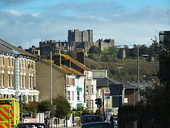
Maxton is an area in the west of Dover, in the county of Kent, England.[1] Maxton also served as the terminus of the tramway system serving the town until its closure in 1938.

Maxton is now a suburb of Dover.[1]

References

[edit]
  1. ^ a b Ordnance Survey: Landranger map sheet 179 Canterbury & East Kent (Dover & Margate) (Map). Ordnance Survey. 2013. ISBN 9780319228784.
[edit]

Media related to Maxton at Wikimedia Commons