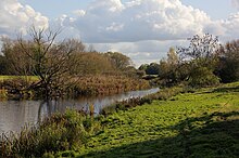
Langham Pond
Appearance
| Site of Special Scientific Interest | |
 | |
| Location | Surrey |
|---|---|
| Grid reference | TQ 002 720[1] |
| Interest | Biological |
| Area | 26.7 hectares (66 acres)[1] |
| Notification | 1986[1] |
| Location map | Magic Map |
Langham Pond is a 26.7-hectare (66-acre) biological Site of Special Scientific Interest north of Egham in Surrey.[1][2]
The pond and its surrounding alluvial meadows on chalk represent a habitat unique in southern England. The pond is the remains of an oxbow lake, formed when a meander of the River Thames was bypassed. The pond contains all four British duckweeds, three nationally scarce plants and a species of fly which has been found nowhere else in Britain, Cerodontha ornata.[3]
References
[edit]- ^ a b c d "Designated Sites View: Langham Pond". Sites of Special Scientific Interest. Natural England. Retrieved 9 November 2018.
- ^ "Map of Langham Pond". Sites of Special Scientific Interest. Natural England. Retrieved 9 November 2018.
- ^ "Langham Pond citation" (PDF). Sites of Special Scientific Interest. Natural England. Retrieved 9 November 2018.
External links
[edit]Wikimedia Commons has media related to Langham Pond.

