Laakdal
Appearance
Laakdal | |
|---|---|
 Eindhout | |
| Coordinates: 51°05′N 05°04′E / 51.083°N 5.067°E | |
| Country | |
| Community | Flemish Community |
| Region | Flemish Region |
| Province | Antwerp |
| Arrondissement | Turnhout |
| Government | |
| • Mayor | Tine Gielis (CD&V) |
| • Governing party/ies | CD&V, PROLaakdal |
| Area | |
• Total | 42.43 km2 (16.38 sq mi) |
| Population (2020-01-01)[1] | |
• Total | 16,186 |
| • Density | 380/km2 (990/sq mi) |
| Postal codes | 2430, 2431 |
| NIS code | 13053 |
| Area codes | 014, 013, 011 |
| Website | www.laakdal.be |
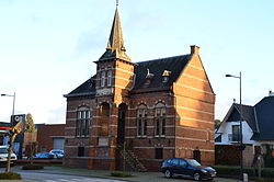
Laakdal (Dutch pronunciation: [ˈlaːɡdɑl]) is a municipality located in the Belgian province of Antwerp. Laakdal was founded in 1977 out of a merger of the towns Veerle, Eindhout and Vorst. The municipality now comprises the towns of Eindhout, Veerle, Vorst, Varendonk and Vorst-Meerlaar (also known as Klein-Vorst).
Census
[edit]In 2021, Laakdal had a total population of 16,293.[2] The total area is 42.48 km2.
Location
[edit]The municipality has 6 neighbouring towns. Clockwise on the compass these are: Geel, Meerhout, Ham, Tessenderlo, Scherpenheuvel-Zichem and Herselt.
Notable people
[edit]References
[edit]- ^ "Bevolking per gemeente op 1 januari 2020". Statbel.
- ^ "Bevolking per statistische sector - Sector 13053". Statistics Belgium. Retrieved 10 May 2022.
External links
[edit] Media related to Laakdal at Wikimedia Commons
- Official website (in Dutch)
- Official website of Eindhout (in Dutch)


