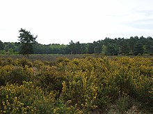
Horsell Common
| Site of Special Scientific Interest | |
 | |
| Location | Surrey |
|---|---|
| Grid reference | TQ 002 606[1] |
| Interest | Biological |
| Area | 152.0 hectares (376 acres)[1] |
| Notification | 1986[1] |
| Location map | Magic Map |
Horsell Common is a 355-hectare (880-acre) open space in Horsell, near Woking in Surrey. It is owned and managed by the Horsell Common Preservation Society.[2] An area of 152 hectares (380 acres) is a biological Site of Special Scientific Interest[1][3] and part of the Thames Basin Heaths Special Protection Area.[4]
In the south-east corner of the common is the former Muslim Burial Ground, now an Islamic Peace Garden. There are Bronze Age barrows, protected heathland and thousands of trees. There are parts of the common all over Horsell, isolated from the rest of the common by roads. There is a large amount of wildlife on the common.

The Sandpit area was the location of the first Martian landing in the H. G. Wells novel The War of the Worlds (1897) .[5]
References
[edit]- ^ a b c d "Designated Sites View: Horsell Common". Sites of Special Scientific Interest. Natural England. Retrieved 9 November 2018.
- ^ "200 Years of Horsell Common". Horsell Common Preservation Society. Archived from the original on 24 April 2010. Retrieved 8 January 2010.
- ^ "Map of Horsell Common". Sites of Special Scientific Interest. Natural England. Retrieved 9 November 2018.
- ^ "Designated Sites View: Thames Basin Heaths". Special Protection Areas. Natural England. Retrieved 2 November 2018.
- ^ The Sandpit, Horsell Common Preservation Society
External links
[edit]- Horsell Common, Horsell Common Preservation Society
- Surrey County Council map of SSSIs


