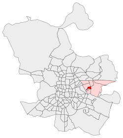
Hellín (Madrid)
Appearance
Hellín | |
|---|---|
 | |
 | |
| Country | Spain |
| Region | Community of Madrid |
| Municipality | Madrid |
| District | San Blas-Canillejas |
| Area | |
• Total | 0.549031 km2 (0.211982 sq mi) |
| Population (2020) | |
• Total | 9,403 |
 | |
Hellín is an administrative neighborhood (barrio) of Madrid belonging to the district of San Blas-Canillejas.
It has an area of 0.549031 km2 (0.211982 sq mi).[1] As of 1 March 2020, it has a population of 9,403.[2]
References
[edit]- ^ "Callejero vigente. Barrios". Ayuntamiento de Madrid.
- ^ "Población por distrito y barrio". Ayuntamiento de Madrid. Retrieved 20 March 2020.
Wikimedia Commons has media related to Hellín neighborhood, Madrid.

