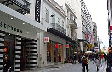
Ermou Street
37°58′35.9″N 23°43′32.6″E / 37.976639°N 23.725722°E

Ermou Street (Greek: Οδός Ερμού, romanized: Odos Ermou, lit. 'Hermes Street') is a one and a half kilometer-long road in central Athens, Greece, connecting Kerameikos archaeological site with the Syntagma Square through Monastiraki, Psiri and Thiseio.
It consists of three sections: The east (from Filellinon Street to Aiolou Street, app. 700m long)[1] which is a pedestrian zone and the city's best-known and busiest shopping street,[2] the middle (from Aiolou Street to Agion Asomaton str.) and the west (from Agion Asomaton to Peiraios Street) a pedestrian zone also.
With fashion shops and shopping centres promoting most international brands, it is in the top five most expensive shopping streets in Europe, and the tenth most expensive retail street in the world.[3] Nearby, the renovated Army Fund building in Panepistimiou Street includes the "Attica" department store and several upmarket designer stores.

One of the oldest churches in Athens, the Byzantine Church of Panagia Kapnikarea is in a small square, on the east section of Ermou Street, while the small Holy Archangels Church lies at the western end, at Agion Asomaton Square.
The western section of the road which was remodeled for the 2004 Olympic Games constitutes the ending of the Grand Promenade, the pedestrian walkway around the Acropolis, part of the city's Archaeological Unification Project.[4]
Ermou Street is twinned with the Okurayama Street in Kanagawa Prefecture - Japan since August 1, 1988.[5]
History
[edit]The street was one of the first roads designed in modern Athens and one of the main axes of Athens' first town plan made by the architects Kleanthis and Schaubert in 1833.[6][7] In contrast to the section from Syntagma Square to Aiolou Street which until now is a base for retail trade, public services cafes and hotels, and a pedestrian zone since 1997 (the pedestrianization started in 1996),[7][8][9] the section of the street from Agion Asomaton street to Peiraios Street was linked with the industrial land use of Peiraios Street in the 19th and 20th century, with wholesale, the operation of Athens and Piraeus Railway and the arterial roads Peiraios Street and Iera Odos Street.
2003 section remodeling
[edit]To improve the image of the area and enhance the archaeological site of Kerameikos and its integration with city life, the section from Agion Asomaton street to Peiraios street was remodeled into a pedestrian way as part of the Grand Promenade project, which is subsumed under the general work for the unification of the archaeological sites of Athens.[10] The remodeling started by the Unification of Archaeological Sites of Athens S.A. on Wednesday 9 July 2003,[11] and now the section constitutes the ending of the Grand Promenade that begins at Panathinaiko Stadium (Vasilissis Olgas Av.) and continues through Dionysiou Areopagitou and Agiou Pavlou streets.[12]
Intersections
[edit]Major intersections from west to east:
- Peiraios Street
- Agion Asomaton (Agion Asomaton Square)
- Athinas Street
- Aiolou Street
- Filellinon Street (Syntagma Square)
See also
[edit]References
[edit]- ^ Charalampidou, Vaso (1998-01-04). "Η ανάπλαση της Ερμού είναι μόνον η αρχή". To Vima (in Greek). Retrieved 22 August 2011.
- ^ "Athens retailers hit hard by crisis". Athens News. 2011-04-10. Archived from the original on 16 March 2011. Retrieved 22 August 2011.
- ^ "Cushman & Wakefield – Global real estate solutions – News & Events". Cushwake.com. 25 October 2006. Archived from the original on 27 September 2007. Retrieved 21 March 2009.
- ^ "Athens Walking Tour: The Grand Promenade". Travel.nationalgeographic.com. Retrieved 22 August 2011.
- ^ "Embassy of Japan in Greece - Japan-Greece Relations". Gr.emb-japan.go.jp. Retrieved 2016-11-19.
- ^ Leonidas Kallivretakis. "Athens in the 19th century: From regional town of the Ottoman Empire to capital of the Kingdom of Greece". Archaeology of the City of Athens. eie.gr. Retrieved 23 August 2011.
- ^ a b Efi Sarantakou (2003). Οδός Ερμού (PDF) (in Greek). courses.arch.ntua.gr. Archived from the original (PDF) on 2022-09-26. Retrieved 22 August 2011.
- ^ Καθυστερεί η πεζοδρόμηση της Ερμού. Rizospastis (in Greek). 1996-05-16. Retrieved 22 August 2011.
- ^ "Athens News Agency: News in Greek (PM), 97-12-30". Athens News Agency (in Greek). hri.org. 1997-12-30. Retrieved 22 August 2011.
Παραδόθηκε και επίσημα ο πεζόδρομος της οδού Ερμού.
- ^ ΠΕΖΟΔΡΟΜΗΣΗ ΤΗΣ ΟΔΟΥ ΕΡΜΟΥ ΑΠΟ ΤΗΝ ΠΛΑΤΕΙΑ ΑΓΙΩΝ ΑΣΩΜΑΤΩΝ ΕΩΣ ΤΗΝ ΟΔΟ ΠΕΙΡΑΙΩΣ (in Greek). astynet.gr. Archived from the original on 23 March 2012. Retrieved 22 August 2011.
- ^ "Remodeling of Ermou street at Kerameekos (section from Hagion Asomaton street to". astynet.gr. 2003-10-12. Archived from the original on 2012-03-23. Retrieved 22 August 2011.
- ^ "Remodeling of Ermou street at Kerameikos (section from Agion Asomaton street to". astynet.gr. Archived from the original on 23 March 2012. Retrieved 22 August 2011.

