Eden, Utah
Eden | |
|---|---|
 | |
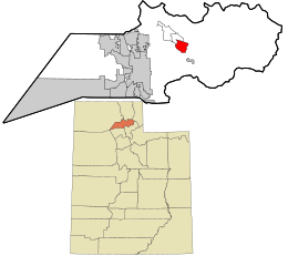
 Location in Weber County and the state of Utah | |
| Coordinates: 41°18′08″N 111°48′31″W / 41.30222°N 111.80861°W | |
| Country | United States |
| State | Utah |
| County | Weber |
| Elevation | 4,944 ft (1,507 m) |
| Population | |
• Total | 600 |
| Time zone | UTC-7 (Mountain (MST)) |
| • Summer (DST) | UTC-6 (MDT) |
| ZIP codes | 84310 |
| Area code(s) | 385, 801 |
| GNIS feature ID | 2584764[1] |
Eden is a census-designated place in Weber County, Utah, United States. It is home to Powder Mountain ski resort. It lies between the North and Middle Fork of the Ogden River, north of Pineview Reservoir, in the Ogden Valley. The population was 600 at the 2010 census. It has a post office with the ZIP code 84310.[3] Eden is part of the Ogden–Clearfield, Utah Metropolitan Statistical Area, as well as the Ogden Valley census county division
History
[edit]
The first home here was a log cabin built in 1857 for summer herdsmen Erastus Bingham and Joseph Hardy. A community was established in 1859 when fifteen families moved in via North Ogden Canyon and Pass. The settlers hired a government surveyor, Washington Jenkins, to plot the town. Jenkins said he thought the area was one of the most beautiful sites he had ever surveyed and suggested the biblical name "Eden". An earlier temporary name was North Fork Town.
Climate
[edit]| Climate data for Eden-Liberty, Utah, 1991–2020 normals, 2010-2020 snowfall: 5195ft (1583m) | |||||||||||||
|---|---|---|---|---|---|---|---|---|---|---|---|---|---|
| Month | Jan | Feb | Mar | Apr | May | Jun | Jul | Aug | Sep | Oct | Nov | Dec | Year |
| Record high °F (°C) | 54 (12) |
59 (15) |
73 (23) |
78 (26) |
89 (32) |
95 (35) |
98 (37) |
98 (37) |
95 (35) |
83 (28) |
72 (22) |
57 (14) |
98 (37) |
| Mean maximum °F (°C) | 44.9 (7.2) |
50.2 (10.1) |
63.7 (17.6) |
68.5 (20.3) |
80.7 (27.1) |
88.7 (31.5) |
93.8 (34.3) |
92.0 (33.3) |
86.9 (30.5) |
75.7 (24.3) |
63.8 (17.7) |
49.5 (9.7) |
94.1 (34.5) |
| Mean daily maximum °F (°C) | 33.0 (0.6) |
37.4 (3.0) |
48.7 (9.3) |
56.2 (13.4) |
66.4 (19.1) |
77.3 (25.2) |
87.2 (30.7) |
85.8 (29.9) |
75.9 (24.4) |
62.8 (17.1) |
46.9 (8.3) |
34.4 (1.3) |
59.3 (15.2) |
| Daily mean °F (°C) | 24.1 (−4.4) |
27.5 (−2.5) |
37.4 (3.0) |
44.4 (6.9) |
52.6 (11.4) |
61.3 (16.3) |
69.6 (20.9) |
68.5 (20.3) |
59.0 (15.0) |
47.6 (8.7) |
35.8 (2.1) |
25.3 (−3.7) |
46.1 (7.8) |
| Mean daily minimum °F (°C) | 15.2 (−9.3) |
17.6 (−8.0) |
26.0 (−3.3) |
32.5 (0.3) |
38.8 (3.8) |
45.2 (7.3) |
51.9 (11.1) |
51.1 (10.6) |
42.0 (5.6) |
32.3 (0.2) |
24.7 (−4.1) |
16.1 (−8.8) |
32.8 (0.5) |
| Mean minimum °F (°C) | −4.6 (−20.3) |
1.9 (−16.7) |
12.7 (−10.7) |
21.2 (−6.0) |
27.3 (−2.6) |
36.3 (2.4) |
43.7 (6.5) |
42.2 (5.7) |
32.5 (0.3) |
18.8 (−7.3) |
10.8 (−11.8) |
−2.2 (−19.0) |
−7.8 (−22.1) |
| Record low °F (°C) | −20 (−29) |
−10 (−23) |
7 (−14) |
17 (−8) |
22 (−6) |
31 (−1) |
37 (3) |
37 (3) |
28 (−2) |
−4 (−20) |
−2 (−19) |
−9 (−23) |
−20 (−29) |
| Average precipitation inches (mm) | 3.40 (86) |
2.76 (70) |
2.64 (67) |
2.79 (71) |
2.75 (70) |
1.89 (48) |
0.90 (23) |
0.97 (25) |
1.70 (43) |
2.95 (75) |
2.49 (63) |
2.96 (75) |
28.2 (716) |
| Average snowfall inches (cm) | 26.8 (68) |
18.3 (46) |
11.8 (30) |
2.7 (6.9) |
0.4 (1.0) |
0.0 (0.0) |
0.0 (0.0) |
0.0 (0.0) |
0.0 (0.0) |
3.2 (8.1) |
13.7 (35) |
22.1 (56) |
99 (251) |
| Source 1: NOAA[4] | |||||||||||||
| Source 2: XMACIS2 (snowfall, records & monthly max/mins)[5] | |||||||||||||
Demographics
[edit]As of the census[2] of 2010, there were 600 people living in the CDP. There were 204 housing units. The racial makeup of the town was 95.8% White, 1.0% Black or African American, 0.2% American Indian and Alaska Native, 0.5% Asian, 0.3% Native Hawaiian and Other Pacific Islander, 1.0% some other race, and 1.2% from two or more races. Hispanic or Latino of any race were 3.2% of the population.
Notable people
[edit]- Taylor Booth (born 2001) – professional soccer player
- David Eccles (1849–1912) – businessman and industrialist[6]
See also
[edit]References
[edit]- ^ a b U.S. Geological Survey Geographic Names Information System: Eden, Utah
- ^ a b "U.S. Census website". United States Census Bureau. Retrieved May 18, 2011.
- ^ USPS – Cities by ZIP Code
- ^ "Eden-Liberty, Utah 1991-2020 Monthly Normals". Retrieved November 19, 2023.
- ^ "xmACIS". National Oceanic and Atmospheric Administration. Retrieved November 19, 2023.
- ^ Arrington, Leonard. "David Eccles". Utah History Encyclopedia. Retrieved September 12, 2020.
External links
[edit]![]() Media related to Eden, Utah at Wikimedia Commons
Media related to Eden, Utah at Wikimedia Commons


