Donner Memorial State Park
| Donner Memorial State Park | |
|---|---|
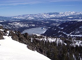
 Donner Lake, with Donner Memorial State Park at the far end, right, viewed from near Donner Peak | |
| Location | Nevada and Placer Counties, California, US |
| Nearest city | Truckee, California |
| Coordinates | 39°19′12″N 120°14′30″W / 39.32000°N 120.24167°W |
| Area | 3,293 acres (13.33 km2) |
| Established | 1928 |
| Governing body | California Department of Parks and Recreation |
Donner Camp | |
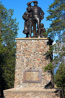
 The Donner Party Memorial at Donner Memorial State Park | |
| Nearest city | Truckee, California |
| Area | California |
| Built | 1846 |
| NRHP reference No. | 66000218[1] |
| CHISL No. | 134[2] |
| Significant dates | |
| Added to NRHP | October 15, 1966 |
| Designated NHL | January 20, 1961[3] |

Donner Memorial State Park is a state park of California, US, preserving the site of the Donner Camp, where members of the ill-fated Donner Party were trapped by weather during the winter of 1846–1847. Caught without shelter or adequate supplies, members of the group resorted to cannibalism to survive. The Sierra Nevada site has been designated a National Historic Landmark. The state park contains the Emigrant Trail Museum and the Pioneer Monument dedicated to the travelers of the Emigrant Trail.
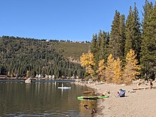
Donner Memorial State Park is located outside Truckee, California. It has 2.5 miles (4.0 km) of hiking trails, campgrounds, and 3 miles (4.8 km) of lake frontage on Donner Lake, east of Donner Pass. The 3,293-acre (1,333 ha) park was established in 1928.[4]
Visitor center
[edit]The Donner Memorial State Park visitor center contains exhibits about the cultural history of the area, including local Native Americans, the Donner Party, and builders of the First transcontinental railroad. Near the museum is the Pioneer Monument and the Donner Party's Murphy family cabin site. Park staff offer hikes, special presentations and campfires by the museum.
Pioneer Monument
[edit]The Pioneer Monument was erected in honor of all who made the difficult trek across the western plains and mountains to reach California during the 1840s. Work on the monument, constructed near the site of the cabins that gave shelter to the Donner Party, began in 1901. On June 6, 1918, in a ceremony that included Donner Party survivors, the Native Sons of the Golden West donated the completed monument and 11 surrounding acres to the State of California.
The plaque on the front of the Pioneer Statue reads:
VIRILE TO RISK AND FIND; KINDLY WITHAL AND A READY HELP. FACING THE BRUNT OF FATE; INDOMITABLE,—UNAFRAID.
The plaque on the rear of the Pioneer Statue reads:
NEAR THIS SPOT STOOD THE BREEN CABIN OF THE PARTY OF EMIGRANTS WHO STARTED FOR CALIFORNIA FROM SPRINGFIELD, ILLINOIS, IN APRIL 1846, UNDER THE LEADERSHIP OF CAPTAIN GEORGE DONNER. DELAYS OCCURRED AND WHEN THE PARTY REACHED THIS LOCALITY, ON OCTOBER 29, THE TRUCKEE PASS EMIGRANT ROAD WAS CONCEALED BY SNOW. THE HEIGHT OF THE SHAFT OF THE MONUMENT INDICATES THE DEPTH OF THE SNOW, WHICH WAS TWENTY-TWO FEET. AFTER FUTILE EFFORTS TO CROSS THE SUMMIT THE PARTY WAS COMPELLED TO ENCAMP FOR THE WINTER. THE GRAVES CABIN WAS SITUATED ABOUT THREE-QUARTERS OF A MILE TO THE EASTWARD, THE MURPHY CABIN ABOUT TWO HUNDRED YARDS SOUTHWEST OF THE MONUMENT, AND THE DONNER TENTS WERE AT THE HEAD OF ALDER CREEK. NINETY PEOPLE WERE IN THE PARTY AND FORTY-TWO PERISHED, MOST OF THEM FROM STARVATION AND EXPOSURE.
IN COMMEMORATION OF THE PIONEERS WHO CROSSED THE PLAINS TO SETTLE IN CALIFORNIA. MONUMENT ERECTED UNDER THE AUSPICES OF THE NATIVE SONS AND THE NATIVE DAUGHTERS OF THE GOLDEN WEST. MONUMENT DEDICATED JUNE 6, 1918
From the museum a trail leads about 200 yards (180 m) to the large granite boulder against which was built the cabin that sheltered members of the Murphy, Pike, Foster, and Eddy families during the winter of 1846–47. A plaque on the boulder's face reads:
THE FACE OF THIS ROCK FORMED THE NORTH END AND THE FIREPLACE OF THE MURPHY CABIN. GENERAL STEPHEN W. KEARNY, ON JUNE 22, 1847, BURIED UNDER THE MIDDLE OF THE CABIN THE BODIES FOUND IN THE VICINITY. FOLLOWING IS A COMPLETE LIST OF THE MEMBERS OF THE DONNER PARTY WHO OCCUPIED THE VARIOUS CABINS AND TENTS.
This is followed by a list of the members of the Donner Party, divided into "Survived" and "Perished." (Some of the information on this plaque is inaccurate, however.)[5]
The Moses Schallenberger plaque reads:
SCHALLENBERGER CABIN SITE \ Near this spot stood a small cabin built by 18-year-old Moses Schallenberger and two other men. They were members of the Stephens-Townsend-Murphy Party of 1844, the first pioneers to take wagons over the Sierra Nevada, opening the Truckee Route of the California Trail. The three men had volunteered to remain behind and guard six of the wagons left here by the main party. \ Due to extreme winter weather conditions and lack of food, the three men agreed to separate. The two older men rejoined the wagon party, but due to his weakened physical condition, Moses Schallenberger chose to remain at the cabin. The young man survived for nearly three months alone in the small cabin during the winter of 1844–45 before being rescued. His cabin would later provide shelter for the Breen family, members of the ill-fated Donner Party, who were stranded here in 1846–47. \ The courage and resolution of Moses Schallenberger during his solitary winter ordeal in this cabin makes him one of the true heroes in the saga of the California Trail. \ Dedicated August 19, 1995 \ Nevada County Historical Landmarks Commission \ Calif. Dept. of Parks and Recreation \ Nev-01-95 \ This monument was made possible through the generosity of many groups and individuals committed to the preservation of the California Trail.
Climate
[edit]The park has either a Mediterranean climate or a humid continental climate (Köppen climate classification Dsb/Csb) with cold, snowy winters and warm, dry summers. Winters are cold with a January average of 27.2 °F (−2.7 °C) and temperatures below 0 °F (−17.8 °C) occur on 3.6 days per year.[6] Most of the precipitation falls during the winter months with an average precipitation of 38.81 inches (986 mm) and an average snowfall of 182.9 inches (465 cm).[6] Summers are dry with warm daytime temperatures (can exceed 90 °F (32.2 °C) on 6.3 days) and cold nighttime temperatures that often reach below 32 °F (0.0 °C).[6] The average high in the warmest month, July is 82.3 °F (27.9 °C) and the average low is 43.5 °F (6.4 °C) with a mean precipitation of only 0.35 inches (0.9 cm). The record low is −28 °F (−33.3 °C) on February 27, 1962, and the record high is 99 °F (37.2 °C) on July 10–11, 2002 and August 9, 1981.[7]
| Climate data for Donner Memorial State Park, California, 1991–2020 normals, extremes 1953–2015 | |||||||||||||
|---|---|---|---|---|---|---|---|---|---|---|---|---|---|
| Month | Jan | Feb | Mar | Apr | May | Jun | Jul | Aug | Sep | Oct | Nov | Dec | Year |
| Record high °F (°C) | 67 (19) |
67 (19) |
72 (22) |
79 (26) |
88 (31) |
95 (35) |
99 (37) |
99 (37) |
96 (36) |
90 (32) |
75 (24) |
67 (19) |
99 (37) |
| Mean maximum °F (°C) | 54.2 (12.3) |
56.1 (13.4) |
61.6 (16.4) |
70.5 (21.4) |
79.8 (26.6) |
85.5 (29.7) |
91.0 (32.8) |
89.9 (32.2) |
85.5 (29.7) |
76.4 (24.7) |
63.9 (17.7) |
52.4 (11.3) |
92.7 (33.7) |
| Mean daily maximum °F (°C) | 41.0 (5.0) |
43.1 (6.2) |
47.8 (8.8) |
53.5 (11.9) |
63.2 (17.3) |
73.0 (22.8) |
82.3 (27.9) |
80.8 (27.1) |
74.5 (23.6) |
62.6 (17.0) |
49.2 (9.6) |
39.1 (3.9) |
59.2 (15.1) |
| Daily mean °F (°C) | 28.4 (−2.0) |
30.2 (−1.0) |
34.8 (1.6) |
39.9 (4.4) |
47.6 (8.7) |
55.5 (13.1) |
62.4 (16.9) |
61.1 (16.2) |
55.2 (12.9) |
45.6 (7.6) |
35.9 (2.2) |
27.6 (−2.4) |
43.7 (6.5) |
| Mean daily minimum °F (°C) | 15.7 (−9.1) |
17.4 (−8.1) |
21.8 (−5.7) |
26.2 (−3.2) |
32.0 (0.0) |
38.0 (3.3) |
42.5 (5.8) |
41.0 (5.0) |
35.9 (2.2) |
28.6 (−1.9) |
22.7 (−5.2) |
16.1 (−8.8) |
28.2 (−2.1) |
| Mean minimum °F (°C) | 0.4 (−17.6) |
0.2 (−17.7) |
6.9 (−13.9) |
15.7 (−9.1) |
23.3 (−4.8) |
28.1 (−2.2) |
33.7 (0.9) |
33.2 (0.7) |
27.0 (−2.8) |
19.7 (−6.8) |
9.0 (−12.8) |
0.6 (−17.4) |
−4.6 (−20.3) |
| Record low °F (°C) | −18 (−28) |
−28 (−33) |
−10 (−23) |
0 (−18) |
10 (−12) |
21 (−6) |
23 (−5) |
20 (−7) |
16 (−9) |
4 (−16) |
−3 (−19) |
−23 (−31) |
−28 (−33) |
| Average precipitation inches (mm) | 6.73 (171) |
6.57 (167) |
6.18 (157) |
2.67 (68) |
2.13 (54) |
0.67 (17) |
0.35 (8.9) |
0.36 (9.1) |
0.49 (12) |
2.19 (56) |
3.57 (91) |
6.90 (175) |
38.81 (986) |
| Average snowfall inches (cm) | 40.0 (102) |
37.7 (96) |
32.9 (84) |
15.4 (39) |
3.4 (8.6) |
0.5 (1.3) |
0.0 (0.0) |
0.0 (0.0) |
0.0 (0.0) |
2.4 (6.1) |
10.1 (26) |
40.5 (103) |
182.9 (466) |
| Average extreme snow depth inches (cm) | 34.1 (87) |
40.4 (103) |
36.9 (94) |
18.7 (47) |
3.8 (9.7) |
0.3 (0.76) |
0.0 (0.0) |
0.0 (0.0) |
0.2 (0.51) |
1.7 (4.3) |
8.6 (22) |
24.8 (63) |
51.7 (131) |
| Average precipitation days (≥ 0.01 in) | 10.7 | 10.3 | 9.7 | 7.4 | 6.6 | 3.2 | 1.3 | 1.6 | 2.4 | 4.3 | 6.5 | 10.5 | 74.5 |
| Average snowy days (≥ 0.1 in) | 8.9 | 8.5 | 6.8 | 4.7 | 1.6 | 0.3 | 0.0 | 0.0 | 0.0 | 1.0 | 3.3 | 7.6 | 42.7 |
| Source 1: NOAA[6] | |||||||||||||
| Source 2: XMACIS2 (mean maxima/minima, snow depth 1981–2010)[7] | |||||||||||||
See also
[edit]References
[edit]- ^ "National Register Information System". National Register of Historic Places. National Park Service. January 23, 2007.
- ^ "Pioneer Monument". Office of Historic Preservation, California State Parks. Retrieved October 10, 2012.
- ^ "Donner Camp". National Historic Landmark summary listing. National Park Service. Archived from the original on November 14, 2007. Retrieved June 17, 2008.
- ^ "California State Park System Statistical Report: Fiscal Year 2009/10" (PDF). California State Parks: 32. Retrieved December 12, 2011.
{{cite journal}}: Cite journal requires|journal=(help) - ^ Johnson, Kristin. "Brief Myths: Murphy cabin plaque". New Light on the Donner Party. Utah Crossroads Chapter, Oregon-California Trails Association. Archived from the original on December 24, 2007. Retrieved December 9, 2007.
western, not northern, wall ... burial did not take place at the Murphy cabin
- ^ a b c d "U.S. Climate Normals Quick Access – Station: Donner MEM SP, CA". National Oceanic and Atmospheric Administration. Retrieved March 4, 2023.
- ^ a b "xmACIS2". National Oceanic and Atmospheric Administration. Retrieved March 4, 2023.
External links
[edit]- State parks of California
- Parks in Nevada County, California
- Donner Party
- History museums in California
- Museums in Nevada County, California
- California Historical Landmarks
- National Historic Landmarks in California
- National Register of Historic Places in Nevada County, California
- History of Nevada County, California
- Protected areas established in 1928
- 1928 establishments in California
- Campgrounds in California
- Protected areas of the Sierra Nevada (United States)
- Temporary populated places on the National Register of Historic Places
- Stephens–Townsend–Murphy Party


