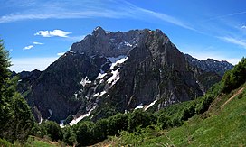
Col Nudo
Appearance
| Col Nudo | |
|---|---|
 Col Nudo northern slopes | |
| Highest point | |
| Elevation | 2,471 m (8,107 ft)[1] |
| Prominence | 1,645 m (5,397 ft)[2][3] |
| Isolation | 11.11 km (6.90 mi) |
| Listing | |
| Coordinates | 46°13′44″N 12°24′05″E / 46.22889°N 12.40139°E |
| Geography | |
| Country | Italy |
| Regions | Veneto and Friuli-Venezia Giulia |
| Parent range | Venetian Prealps |
The Col Nudo is a mountain in the Alps located in Italy. It is the highest peak of the Venetian Prealps and the 30th most prominent summit of the Alps.
Geography
[edit]Administratively the mountain is divided between the Italian regions of Friuli-Venezia Giulia (province of Pordenone) and Veneto (province of Belluno).
SOIUSA classification
[edit]According to SOIUSA (International Standardized Mountain Subdivision of the Alps) the mountain can be classified in the following way:[4]
- main part = Eastern Alps
- major sector = Central Eastern Alps
- section = Venetian Prealps
- subsection = Prealpi Bellunesi
- supergroup = Catena Cavallo-Visentin
- group = Gruppo Col Nudo-Cavallo
- subgroup = Sottogruppo del Col Nudo
- code = II/C-32.II-B.2.a
References
[edit]- ^ "Topographic map of Col Nudo". opentopomap.org. Retrieved 2023-07-03.
- ^ "Col Nudo, Italy". Peakbagger.com. Retrieved 2023-07-03.
- ^ Key col:Passo di San Osvaldo - 827 m
- ^ Marazzi, Sergio (2005). Atlante Orografico delle Alpi. SOIUSA (in Italian). Priuli & Verlucca. p. 294. ISBN 978-88-8068-273-8.
External links
[edit]- Photo of Col Nudo on www.summitpost.org


