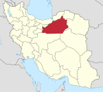
Central District (Shahrud County)
Appearance
Central District (Shahrud County)
Persian: بخش مرکزی شهرستان شاهرود | |
|---|---|
| Coordinates: 35°21′13″N 55°08′26″E / 35.35361°N 55.14056°E[1] | |
| Country | Iran |
| Province | Semnan |
| County | Shahrud |
| Capital | Shahrud |
| Population (2016)[2] | |
• Total | 166,963 |
| Time zone | UTC+3:30 (IRST) |
The Central District of Shahrud County (Persian: بخش مرکزی شهرستان شاهرود) is in Semnan province, Iran. Its capital is the city of Shahrud.[3]
History
[edit]After the 2011 National Census, the village of Ruyan was elevated to the status of the city of Rudiyan.[4]
Demographics
[edit]Population
[edit]At the time of the 2006 census, the district's population was 142,663 in 39,805 households.[5] The following census in 2011 counted 155,326 people in 45,464 households.[6] The 2016 census measured the population of the rural district as 166,963 inhabitants in 52,694 households.[2]
Administrative divisions
[edit]| Administrative Divisions | 2006[5] | 2011[6] | 2016[2] |
|---|---|---|---|
| Dehmolla RD | 2,197 | 1,797 | 2,317 |
| Howmeh RD | 10,008 | 9,555 | 7,366 |
| Torud RD | 3,542 | 3,500 | 3,381 |
| Rudiyan (city) | 3,770 | ||
| Shahrud (city) | 126,916 | 140,474 | 150,129 |
| Total | 142,663 | 155,326 | 166,963 |
| RD = Rural District | |||
See also
[edit]References
[edit]- ^ OpenStreetMap contributors (25 April 2023). "Central District (Shahrud County)" (Map). OpenStreetMap (in Persian). Retrieved 25 April 2023.
- ^ a b c "Census of the Islamic Republic of Iran, 1395 (2016)". AMAR (in Persian). The Statistical Center of Iran. p. 20. Archived from the original (Excel) on 17 November 2020. Retrieved 19 December 2022.
- ^ Habibi, Hassan (21 June 1369). "Approval of the organization and chain of citizenship of the elements and units of the national divisions of Semnan province, centered in Semnan city". Lamtakam (in Persian). Ministry of Interior, Defense Political Commission of the Government Council. Archived from the original on 2 January 2024. Retrieved 2 January 2024.
- ^ "Renaming and upgrading of Ruyan village in Shahrud County to Rudiyan city". Mehr News (in Persian). Ministry of Interior, Board of Ministers. 22 March 1400. Archived from the original on 4 March 2016. Retrieved 25 April 2023.
- ^ a b "Census of the Islamic Republic of Iran, 1385 (2006)". AMAR (in Persian). The Statistical Center of Iran. p. 20. Archived from the original (Excel) on 20 September 2011. Retrieved 25 September 2022.
- ^ a b "Census of the Islamic Republic of Iran, 1390 (2011)". Syracuse University (in Persian). The Statistical Center of Iran. p. 20. Archived from the original (Excel) on 20 January 2023. Retrieved 19 December 2022.


