Canyon Fire (2016)
| Canyon Fire (2016) | |
|---|---|
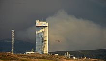
 Smoke rises from the Canyon Fire with Launch Complex 3 in the foreground. | |
| Date(s) |
|
| Location | Vandenberg Air Force Base, Santa Barbara County, California |
| Coordinates | 34°36′43″N 120°34′05″W / 34.612°N 120.568°W |
| Statistics[2] | |
| Burned area | 12,742 acres (51.6 km2)[1] |
| Impacts | |
| Deaths | 1 |
| Damage | $12 million |
| Map | |
The Canyon Fire was a wildfire that burned on Vandenberg Space Force Base in Santa Barbara County, California during September 2016. By the time the fire was contained on September 24, it had burned 12,742 acres (51.6 km2) of land.[1] Due to the nature of the activities that take place on the Base, there were a number of unique challenges posed during the fire including the presence of potentially hazardous materials.[3]
Progression
[edit]
The fire broke out September 17 and quickly grew to over 500 acres (2.0 km2). Due to the location of the fire, burning in a remote canyon on the southern half of the base, access was difficult for fire crews.[4] On September 18 the fire jumped to over 2,200 acres (8.9 km2) prompting evacuation warnings for homes on San Miguelito Canyon south of Lompoc and east of the base.[5] By mid-afternoon on September 19 the fire had grown to over 4,528 acres (18.3 km2) and with no containment was continuing to burn with a moderate rate of spread.[6]
As the fire continued to spread, firefighters were faced with a number of unique challenges. Base officials warned that there was possibly unexploded ordnance that was left over from the days when the base was used during World War II and the Korean War.[3] By the morning of September 20, the fire had been estimated at 10,542 acres (42.7 km2) in size with only 18% of the fire contained.[7]
On September 21, a Ventura County OES water tender assigned to the fire crashed on Highway 246 just outside Lompoc.[8] The crash killed one firefighter and sent the second to the hospital with minor injuries.[8] The individual was identified as engineer Ryan Osler.[9]
The fire was fully contained on September 24 after burning 12,742 acres (51.6 km2).[1][10]
Effects
[edit]A United Launch Alliance Atlas V carrying the WorldView-4 earth observation satellite that was set to launch on September 18 from Vandenberg AFB Space Launch Complex 3 had to be delayed.[11] According to the Emergency Operations Center commander, base procedures require firefighting crews to be standing by for every launch, thus the launch was delayed so that all resources could concentrate on the growing fire.[11] While all fires at Vandenberg were contained by September 27, facilities and instrumentation needed to be surveyed for damage and, due to the delays, the launch did not occur until November 11, 2016.[10][12][13]
The fire also caused widespread power outages in multiple facilities on the base including at least one fire station which had to operate on generator power.[6]
See also
[edit]References
[edit]- ^ a b c Hamm, Keith (September 29, 2016). "Vandenberg Beats Back Four Separate Fires". Santa Barbara Independent. Retrieved September 29, 2016.
- ^ Scully, Janene (September 19, 2016). "Canyon Fire Chars More Than 4,500 Acres at Vandenberg Air Force Base". Noozhawk. Retrieved September 19, 2016.
- ^ a b Scully, Janene (September 20, 2016). "Canyon Fire at Vandenberg Air Force Base Presents Unique Challenges". Noozhawk. Retrieved September 20, 2016.
- ^ Hamilton, Matt; Rocha, Veronica (September 19, 2016). "Central California wildfire swells to 4,500 acres at Vandenberg Air Force Base". Los Angeles Times. Retrieved September 19, 2016.
- ^ Slyke, Matt Van (September 18, 2016). "Update: Canyon Fire at Vandenberg Air Force Base at 2,200 acres 0% contained". KSBY. Archived from the original on September 20, 2016. Retrieved September 19, 2016.
- ^ a b "Crews Fight Vandenberg AFB Wildfland Fire". Vandenberg Air Force Base. Retrieved September 19, 2016.
- ^ Garcia, Ernesto (September 19, 2016). "10,542 acres burned in Canyon Fire at VAFB, 18% contained". KSBY. Archived from the original on September 21, 2016. Retrieved September 20, 2016.
- ^ a b Scully, Janene (September 21, 2016). "Ventura County Firefighter Assigned to Canyon Fire Dies in Rollover Crash East of Lompoc". Noozhawk. Retrieved September 21, 2016.
- ^ Herndon, Kathrene (September 21, 2016). "Firefighter killed, another injured in crash near Lompoc". KSBY. Archived from the original on September 22, 2016. Retrieved September 21, 2016.
- ^ a b Jacobson, Willis (September 28, 2016). "VAFB commander addresses fires at town hall forum". Santa Maria Times. Retrieved September 29, 2016.
- ^ a b Scully, Janene (September 18, 2016). "Atlas V Rocket Launch Attempt Delayed Due to Fire at Vandenberg AFB". Noozhawk. Retrieved September 19, 2016.
- ^ Scully, Janene (September 27, 2016). "Vandenberg AFB Beefs Up Security In Wake of Fires; Damage Still Unknown". Noozhawk. Retrieved September 29, 2016.
- ^ Swarts, Phillip (November 11, 2016). "WorldView-4 launches successfully after two-month fire delay". SpaceNews. Retrieved November 12, 2016.


