Auerbach in der Oberpfalz
Appearance
Auerbach in der Oberpfalz | |
|---|---|
 Center of the town with the town hall | |
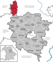
Location of Auerbach in der Oberpfalz within Amberg-Sulzbach district  | |
| Coordinates: 49°41′N 11°37′E / 49.683°N 11.617°E | |
| Country | Germany |
| State | Bavaria |
| Admin. region | Oberpfalz |
| District | Amberg-Sulzbach |
| Government | |
| • Mayor (2020–26) | Joachim Neuß[1] (FW) |
| Area | |
• Total | 70.33 km2 (27.15 sq mi) |
| Elevation | 435 m (1,427 ft) |
| Population (2023-12-31)[2] | |
• Total | 9,127 |
| • Density | 130/km2 (340/sq mi) |
| Time zone | UTC+01:00 (CET) |
| • Summer (DST) | UTC+02:00 (CEST) |
| Postal codes | 91275 |
| Dialling codes | 09643 |
| Vehicle registration | AS |
| Website | www.auerbach.de |
Auerbach in der Oberpfalz (German pronunciation: [ˈaʊɐbax ɪn dɐ ˈoːbɐpfalts] ) is a town in the Amberg-Sulzbach district, Bavaria, Germany. In the subdivision Michelfeld there was a Benedictine monastery which is now a nursing home.
Geography
[edit]It is located 45 km northeast of Nuremberg. Apart from the town Auerbach the municipality consists of the following villages:[3]
- Bernreuth
- Degelsdorf
- Dornbach
- Espamühle
- Gunzendorf
- Hagenohe
- Hammerberg
- Hämmerlmühle
- Lehnershof
- Leiten
- Ligenz
- Michelfeld
- Mühldorf
- Nasnitz
- Neumühle
- Niedernhof
- Nitzlbuch
- Ohrenbach
- Ortlesbrunn
- Pferrach
- Ranna
- Ranzenthal
- Rauhenstein
- Reichenbach
- Rosenhof
- Rußhütte
- Saaß
- Sackdilling
- Sägmühle
- Sand
- Speckmühle
- Staubershammer
- Steinamwasser
- Weidlwang
- Welluck
- Zogenreuth
Mayor
[edit]Since May 2008 Joachim Neuß is the mayor. Helmut Ott was the mayor 1996–2008.[4]
Town twinnings
[edit] Laneuveville-devant-Nancy, Lorraine, France
Notable citizens
[edit]- Johann Baptist Metz (1928-2019), Catholic theologian
- Heinrich Stromer (1476-1542), professor at the Leipzig university, physician and founder of Auerbach's Cellar.
- Johann Michael Doser (1678–1756) artist, mainly in the fields of wood carvings und sculptures for altars
- Maurus von Schenkl (1749-1816), Benedictine theologian, librarian and canonist,
References
[edit]- ^ Liste der ersten Bürgermeister/Oberbürgermeister in kreisangehörigen Gemeinden, Bayerisches Landesamt für Statistik, 15 July 2021.
- ^ Genesis Online-Datenbank des Bayerischen Landesamtes für Statistik Tabelle 12411-003r Fortschreibung des Bevölkerungsstandes: Gemeinden, Stichtag (Einwohnerzahlen auf Grundlage des Zensus 2011).
- ^ "Ortsteile mit Postleitzahl". Retrieved 15 February 2024.
- ^ ""Altbürgermeister Helmut Ott hat Stadt geprägt"".
Wikimedia Commons has media related to Auerbach in der Oberpfalz.


