Size of this preview: 579 × 600 pixels. Other resolutions: 232 × 240 pixels | 463 × 480 pixels | 741 × 768 pixels | 1,087 × 1,126 pixels.
Original file (1,087 × 1,126 pixels, file size: 881 KB, MIME type: image/png)
File history
Click on a date/time to view the file as it appeared at that time.
| Date/Time | Thumbnail | Dimensions | User | Comment | |
|---|---|---|---|---|---|
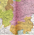
| current | 12:08, 12 February 2008 |  | 1,087 × 1,126 (881 KB) | El bes | {{Information |Description= Duchy of Bajovaria, margravate of Ostarrich and duchy of Carantania around the year 1000 AD (crop of the map ''Heiliges Römisches Reich um 1000'') |Source= Allgemeiner historischer Handatlas |Date= 1886 |Author= Gustav Droysen |
File usage
The following 3 pages use this file:
Global file usage
The following other wikis use this file:
- Usage on arz.wikipedia.org
- Usage on bg.wikipedia.org
- Usage on ca.wikipedia.org
- Usage on de.wikipedia.org
- Usage on el.wikipedia.org
- Usage on es.wikipedia.org
- Usage on et.wikipedia.org
- Usage on fr.wikipedia.org
- Usage on it.wikipedia.org
- Usage on lt.wikipedia.org
- Usage on no.wikipedia.org
- Usage on ro.wikipedia.org
- Usage on ru.wikipedia.org
- Usage on vi.wikipedia.org
- Usage on www.wikidata.org
