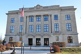
Brown County, Kansas
 | |
| Math | sir |
|---|---|
| Enwyd ar ôl | Albert G. Brown |
| Prifddinas | Hiawatha |
| Poblogaeth | 9,508 |
| Sefydlwyd | |
| Cylchfa amser | Cylchfa Amser Canolog |
| Daearyddiaeth | |
| Gwlad | |
| Arwynebedd | 1,482 km² |
| Talaith | Kansas |
| Yn ffinio gyda | Richardson County, Doniphan County, Atchison County, Jackson County, Nemaha County |
| Cyfesurynnau | 39.8°N 95.6°W |
 | |
Sir yn nhalaith Kansas, Unol Daleithiau America yw Brown County. Cafodd ei henwi ar ôl Albert G. Brown. Sefydlwyd Brown County, Kansas ym 1855 a sedd weinyddol y sir (a elwir weithiau'n 'dref sirol' neu'n 'brifddinas y sir') yw Hiawatha.
Mae ganddi arwynebedd o 1,482 cilometr sgwâr. Allan o'r arwynebedd hwn, y canran o ffurfiau dyfrol, megis llynnoedd ac afonydd, yw 0.2% . Yn ôl cyfrifiad y wlad, poblogaeth y sir yw: 9,508 (1 Ebrill 2020)[1]. Mewn cymhariaeth, yn 2016 roedd poblogaeth Caerdydd yn 361,462 a Rhyl tua 26,000.[2]
Mae'n ffinio gyda Richardson County, Doniphan County, Atchison County, Jackson County, Nemaha County. Ceir 9 cylchfa amser yn UDA, ac mae'r sir hon yn perthyn i'r cylchfa amser a elwir yn Cylchfa Amser Canolog. Cedwir rhestr swyddogol o henebion ac adeiladau cofrestredig y sir yn: National Register of Historic Places listings in Brown County, Kansas.
 |
|
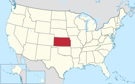
| Map o leoliad y sir o fewn Kansas |
Lleoliad Kansas o fewn UDA |
Ceir sawl sir o’r un enw gan gynnwys:
- Brown County, De Dakota
- Brown County, Illinois
- Brown County, Indiana
- Brown County, Kansas
- Brown County, Minnesota
- Brown County, Nebraska
- Brown County, Ohio
- Brown County, Texas
- Brown County, Wisconsin
Trefi mwyaf
[golygu | golygu cod]Mae gan y sir yma boblogaeth o tua 9,508 (1 Ebrill 2020)[1]. Dyma rai o'r dinasoedd, trefi neu gymunedau mwyaf poblog y sir:
Rhestr Wicidata:
| Tref neu gymuned | Poblogaeth | Arwynebedd |
|---|---|---|
| Hiawatha | 3280[3] | 6.69558[4] 6.700585[5] |
| Horton | 1523[3] | 4.659541[4] 4.659659[5] |
| Powhattan Township | 849[3] | 89.82 |
| Hiawatha Township | 616[3] | 63.57 |
| Walnut Township | 560[3] | 62.49 |
| Mission Township | 550[3] | 85.08 |
| Morrill Township | 491[3] | 40.7 |
| Washington Township | 471[3] | 44.99 |
| Robinson Township | 363[3] | 44.87 |
| Irving Township | 315[3] | 53.01 |
| Hamlin Township | 275[3] | 40.9 |
| Everest | 265[3] | 0.662968[4] 0.662969[5] |
| Fairview | 240[3] | 0.936061[4] 0.952111[5] |
| Morrill | 218[3] | 0.488854[4][5] |
| Padonia Township | 204[3] | 41.36 |
| |||||
Cyfeiriadau
[golygu | golygu cod]- ↑ 1.0 1.1 https://data.census.gov/cedsci/table?t=Populations%20and%20People&g=0100000US,%241600000&y=2020. Cyfrifiad yr Unol Daleithiau 2020. golygydd: Biwro Cyfrifiad yr Unol Daleithiau. dyddiad cyrchiad: 1 Ionawr 2022.
- ↑ statswales.gov.wales; adalwyd 25 Mawrth 2020.
- ↑ 3.00 3.01 3.02 3.03 3.04 3.05 3.06 3.07 3.08 3.09 3.10 3.11 3.12 3.13 3.14 https://data.census.gov/cedsci/table?t=Populations%20and%20People&g=0100000US,%241600000&y=2020
- ↑ 4.0 4.1 4.2 4.3 4.4 2016 U.S. Gazetteer Files
- ↑ 5.0 5.1 5.2 5.3 5.4 2010 U.S. Gazetteer Files


