Niigata (city)
Appearance
(Redirected from Niigata)
Niigata
新潟 | |
|---|---|
| 新潟市 · City of Niigata[1] | |
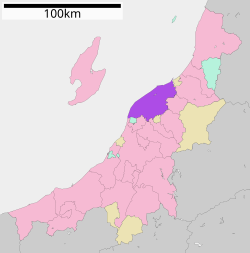
 Location of Niigata in Niigata | |
| Coordinates: 37°54′58.3″N 139°2′11″E / 37.916194°N 139.03639°E | |
| Country | Japan |
| Region | Chūbu |
| Prefecture | Niigata |
| Government | |
| • Mayor | Akira Shinoda |
| Area | |
| • Total | 726.09 km2 (280.34 sq mi) |
| Population (January 31, 2012) | |
| • Total | 804,193 |
| • Density | 1,107.57/km2 (2,868.6/sq mi) |
| Symbols | |
| • Tree | Willow |
| • Flower | Tulip |
| Time zone | UTC+9 (Japan Standard Time) |
| City hall address | 1-602-1 Gakkōchō-dōri, Chūō-ku, Niigata-shi, Niigata-ken 951-8550 |
| Website | www |
Niigata (新潟市, Niigata-shi) is the capital city of Niigata Prefecture in Japan.[2] The port city is on the island of Sea of Japan.[3] The city has the mouth of Shinano River which is the longest river in Japan.[4]
Wards
[change | change source]Niigata has eight neighborhoods or wards (ku).[5]
- Kita Ward (北区, Kita-ku)
- Akiha Ward (秋葉区, Akiha-ku)
- Higashi Ward (東区, Higashi-ku)
- Minami Ward (南区, Minami-ku)
- Chuo Ward (中央区, Chūō-ku)
- Nishi Ward (西区, Nishi-ku)
- Konan Ward (江南区, Kōnan-ku)
- Nishikan Ward (西蒲区, Nishikan-ku)
History
[change | change source]On April 1, 2007 Niigata City became the largest Nihonkai coast city as a government-designated city.
Related pages
[change | change source]References
[change | change source]- ↑ "Niigata's official English Name". Archived from the original on 2015-09-23. Retrieved 2012-07-03.
- ↑ Nussbaum, Louis-Frédéric. (2005). "Niigata" in Japan Encyclopedia, p. 711.
- ↑ Nussbaum, "Niigata-ken" in Japan Encyclopedia, p. 711.
- ↑ "Shinano," Encyclopædia Britannica. Retrieved 2012-6-19.
- ↑ Niigata City, see map at right of city homepage (in Japanese); retrieved 201-7-9.
- ↑ "ALBIREX NIIGATA OFFICIAL WEBSITE". Archived from the original on 2015-09-23. Retrieved 2012-07-03.
Other websites
[change | change source]![]() Media related to Niigata, Niigata at Wikimedia Commons
Media related to Niigata, Niigata at Wikimedia Commons


