38°03′14″N 122°12′10″W / 38.05389°N 122.20278°W
Eckley | |
|---|---|
Former settlement | |
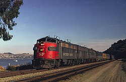
 The City of San Francisco at Eckley in 1971 | |
| Coordinates: 38°03′14″N 122°12′10″W / 38.05389°N 122.20278°W | |
| Country | United States |
| State | California |
| County | Contra Costa County |
| Elevation | 10 ft (3 m) |
Eckley is an area in Contra Costa County, California, which served as a train-ferry landing for crossings of the Carquinez Strait prior to the opening of the Benicia-Martinez railroad bridge. It lay on the Southern Pacific Railroad 4.5 miles (7.2 km) northwest of Martinez,[2] at an elevation of 10 feet (3 m).
The place's name is in honor of Commodore John L. Eckley who established a yacht harbor at the cove here.[2]
References
edit- ^ U.S. Geological Survey Geographic Names Information System: Eckley, California
- ^ a b Durham, David L. (1998). California's Geographic Names: A Gazetteer of Historic and Modern Names of the State. Clovis, Calif.: Word Dancer Press. p. 628. ISBN 1-884995-14-4.
External links
edit- Aerial view in Google Maps
- Port Costa — on Carquinez Strait.
- U.S. Geological Survey Geographic Names Information System: Eckley, California

